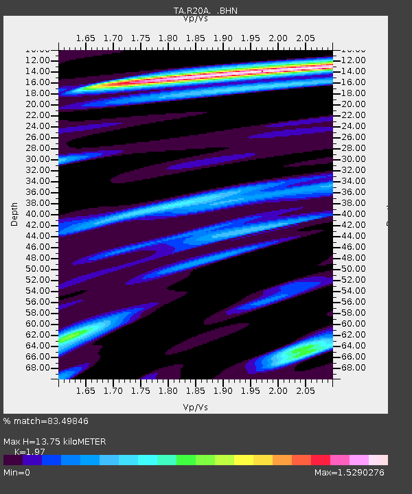
R20A Redvale, CO, USA - Earthquake Result Viewer
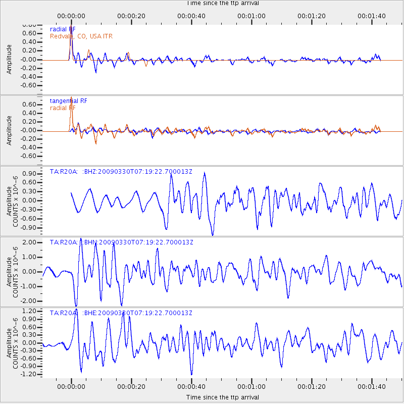
Earthquake location: Kodiak Island Region, Alaska
Earthquake latitude/longitude: 56.5/-152.7
Earthquake time(UTC): 2009/03/30 (089) 07:13:07 GMT
Earthquake Depth: 21 km
Earthquake Magnitude: 5.9 MB, 5.9 MS, 5.9 MW, 5.9 MW
Earthquake Catalog/Contributor: WHDF/NEIC
Network: TA USArray Transportable Network (new EarthScope stations)
Station: R20A Redvale, CO, USA
Lat/Lon: 38.19 N/108.38 W
Elevation: 2003 m
Distance: 34.4 deg
Az: 103.084 deg
Baz: 316.795 deg
Ray Param: 0.07771019
Estimated Moho Depth: 13.75 km
Estimated Crust Vp/Vs: 1.97
Assumed Crust Vp: 6.291 km/s
Estimated Crust Vs: 3.193 km/s
Estimated Crust Poisson's Ratio: 0.33
Radial Match: 83.49846 %
Radial Bump: 400
Transverse Match: 65.50289 %
Transverse Bump: 400
SOD ConfigId: 2658
Insert Time: 2010-03-06 12:26:58.557 +0000
GWidth: 2.5
Max Bumps: 400
Tol: 0.001

Signal To Noise

ChannelStoNSTALTA
TA:R20A: :BHN:20090330T07:19:22.700013Z6.00136851.2900005E-62.1495106E-7
TA:R20A: :BHE:20090330T07:19:22.700013Z3.4385846.76991E-71.9688075E-7
TA:R20A: :BHZ:20090330T07:19:22.700013Z2.5196975.2801613E-72.095554E-7
Arrivals
Ps2.3 SECOND
PpPs6.1 SECOND
PsPs/PpSs8.3 SECOND