You are here: Home > Network List > TA - USArray Transportable Network (new EarthScope stations) Stations List
> Station R20A Redvale, CO, USA > Earthquake Result Viewer
R20A Redvale, CO, USA - Earthquake Result Viewer
| Earthquake location: |
Off Coast Of Ecuador |
| Earthquake latitude/longitude: |
1.4/-85.2 |
| Earthquake time(UTC): |
2009/05/10 (130) 01:16:06 GMT |
| Earthquake Depth: |
6.0 km |
| Earthquake Magnitude: |
5.5 MB, 5.7 MS, 6.1 MW, 6.1 MW |
| Earthquake Catalog/Contributor: |
WHDF/NEIC |
|
| Network: |
TA USArray Transportable Network (new EarthScope stations) |
| Station: |
R20A Redvale, CO, USA |
| Lat/Lon: |
38.19 N/108.38 W |
| Elevation: |
2003 m |
|
| Distance: |
42.4 deg |
| Az: |
332.557 deg |
| Baz: |
144.219 deg |
| Ray Param: |
0.07322655 |
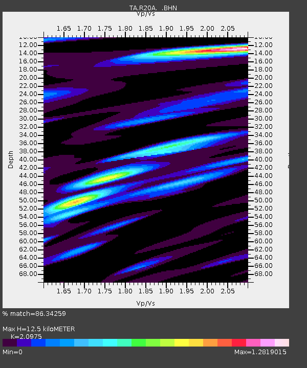
| Estimated Moho Depth: |
12.5 km |
| Estimated Crust Vp/Vs: |
2.10 |
| Assumed Crust Vp: |
6.291 km/s |
| Estimated Crust Vs: |
2.999 km/s |
| Estimated Crust Poisson's Ratio: |
0.35 |
|
| Radial Match: |
86.34259 % |
| Radial Bump: |
396 |
| Transverse Match: |
74.00361 % |
| Transverse Bump: |
400 |
| SOD ConfigId: |
2760 |
| Insert Time: |
2010-03-06 12:27:07.852 +0000 |
| GWidth: |
2.5 |
| Max Bumps: |
400 |
| Tol: |
0.001 |
|
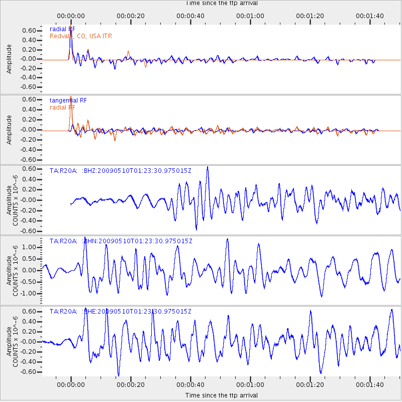
Signal To Noise
| Channel | StoN | STA | LTA |
| TA:R20A: :BHN:20090510T01:23:30.975015Z | 3.245801 | 4.7238527E-7 | 1.4553736E-7 |
| TA:R20A: :BHE:20090510T01:23:30.975015Z | 4.0509324 | 1.9649084E-7 | 4.8505093E-8 |
| TA:R20A: :BHZ:20090510T01:23:30.975015Z | 2.4963946 | 1.2811685E-7 | 5.1320757E-8 |
| Arrivals |
| Ps | 2.3 SECOND |
| PpPs | 5.8 SECOND |
| PsPs/PpSs | 8.1 SECOND |


