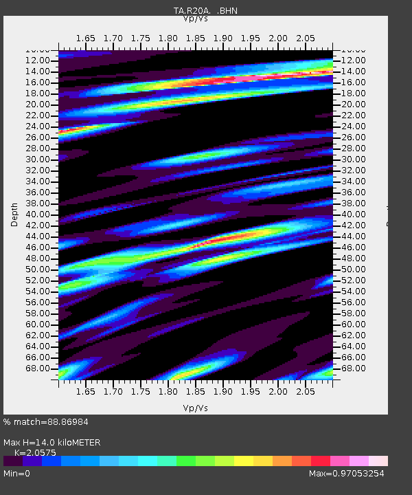
R20A Redvale, CO, USA - Earthquake Result Viewer
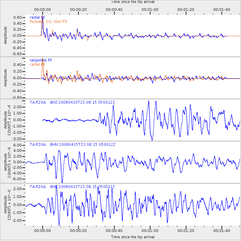
Earthquake location: Andreanof Islands, Aleutian Is.
Earthquake latitude/longitude: 51.9/-179.4
Earthquake time(UTC): 2008/04/15 (106) 22:59:51 GMT
Earthquake Depth: 10 km
Earthquake Magnitude: 6.1 MB, 6.4 MS, 6.4 MW, 6.4 MW
Earthquake Catalog/Contributor: WHDF/NEIC
Network: TA USArray Transportable Network (new EarthScope stations)
Station: R20A Redvale, CO, USA
Lat/Lon: 38.19 N/108.38 W
Elevation: 2003 m
Distance: 50.0 deg
Az: 76.386 deg
Baz: 310.094 deg
Ray Param: 0.068317324
Estimated Moho Depth: 14.0 km
Estimated Crust Vp/Vs: 2.06
Assumed Crust Vp: 6.291 km/s
Estimated Crust Vs: 3.057 km/s
Estimated Crust Poisson's Ratio: 0.35
Radial Match: 88.86984 %
Radial Bump: 400
Transverse Match: 86.587845 %
Transverse Bump: 400
SOD ConfigId: 2504
Insert Time: 2010-03-06 12:27:12.379 +0000
GWidth: 2.5
Max Bumps: 400
Tol: 0.001

Signal To Noise

ChannelStoNSTALTA
TA:R20A: :BHN:20080415T23:08:15.050012Z7.4954431.3594768E-61.8137378E-7
TA:R20A: :BHE:20080415T23:08:15.050012Z3.52407775.3559785E-71.5198242E-7
TA:R20A: :BHZ:20080415T23:08:15.050012Z3.88047124.3373012E-71.1177254E-7
Arrivals
Ps2.5 SECOND
PpPs6.5 SECOND
PsPs/PpSs9.0 SECOND