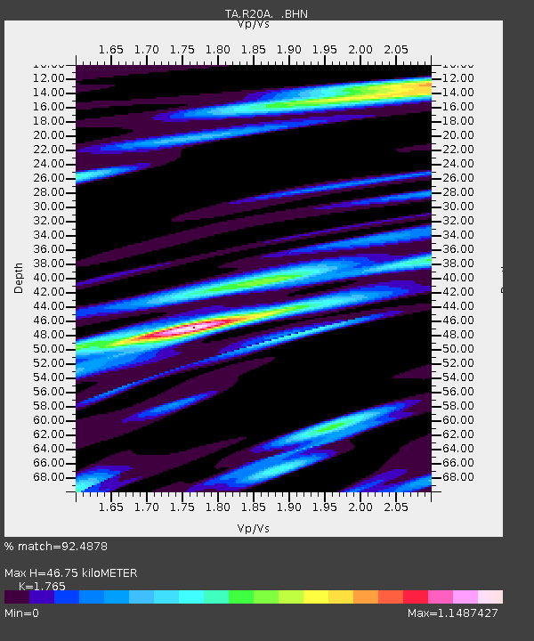
R20A Redvale, CO, USA - Earthquake Result Viewer
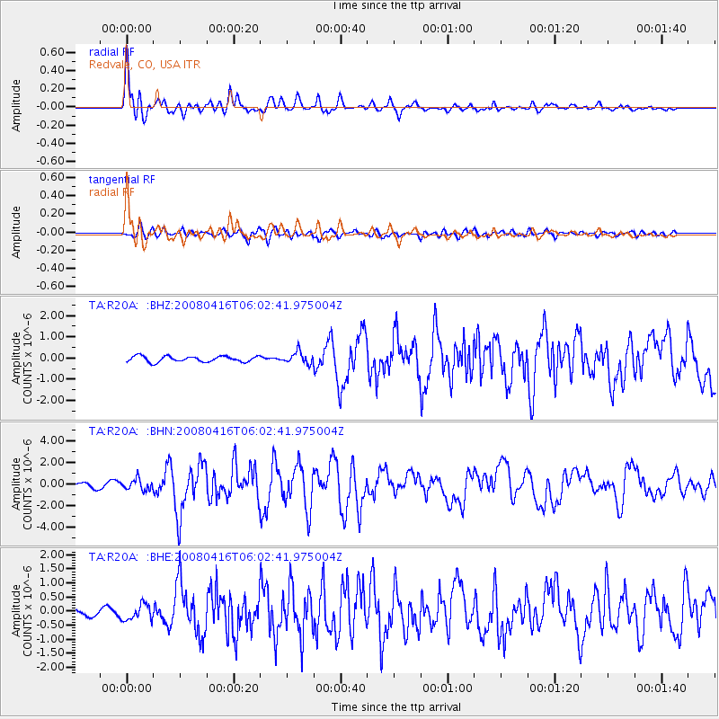
Earthquake location: Andreanof Islands, Aleutian Is.
Earthquake latitude/longitude: 51.9/-179.2
Earthquake time(UTC): 2008/04/16 (107) 05:54:19 GMT
Earthquake Depth: 13 km
Earthquake Magnitude: 6.1 MB, 6.5 MS, 6.6 MW, 6.6 MW
Earthquake Catalog/Contributor: WHDF/NEIC
Network: TA USArray Transportable Network (new EarthScope stations)
Station: R20A Redvale, CO, USA
Lat/Lon: 38.19 N/108.38 W
Elevation: 2003 m
Distance: 49.9 deg
Az: 76.534 deg
Baz: 310.088 deg
Ray Param: 0.068387434
Estimated Moho Depth: 46.75 km
Estimated Crust Vp/Vs: 1.76
Assumed Crust Vp: 6.291 km/s
Estimated Crust Vs: 3.564 km/s
Estimated Crust Poisson's Ratio: 0.26
Radial Match: 92.4878 %
Radial Bump: 400
Transverse Match: 78.15873 %
Transverse Bump: 400
SOD ConfigId: 2504
Insert Time: 2010-03-06 12:27:15.540 +0000
GWidth: 2.5
Max Bumps: 400
Tol: 0.001

Signal To Noise

ChannelStoNSTALTA
TA:R20A: :BHN:20080416T06:02:41.975004Z2.65216265.0305374E-71.896768E-7
TA:R20A: :BHE:20080416T06:02:41.975004Z1.92538432.8142756E-71.4616695E-7
TA:R20A: :BHZ:20080416T06:02:41.975004Z2.05661582.7572742E-71.340685E-7
Arrivals
Ps6.0 SECOND
PpPs19 SECOND
PsPs/PpSs25 SECOND