You are here: Home > Network List > YX16 - Raton Basin UNM Broadband Network Stations List
> Station UNM4 NW Corner of NM Stations > Earthquake Result Viewer
UNM4 NW Corner of NM Stations - Earthquake Result Viewer
| Earthquake location: |
Near East Coast Of Kamchatka |
| Earthquake latitude/longitude: |
51.6/157.9 |
| Earthquake time(UTC): |
2018/07/06 (187) 01:40:08 GMT |
| Earthquake Depth: |
80 km |
| Earthquake Magnitude: |
6.1 Mwp |
| Earthquake Catalog/Contributor: |
NEIC PDE/us |
|
| Network: |
YX Raton Basin UNM Broadband Network |
| Station: |
UNM4 NW Corner of NM Stations |
| Lat/Lon: |
36.99 N/105.06 W |
| Elevation: |
2784 m |
|
| Distance: |
66.0 deg |
| Az: |
60.428 deg |
| Baz: |
317.364 deg |
| Ray Param: |
0.05770691 |
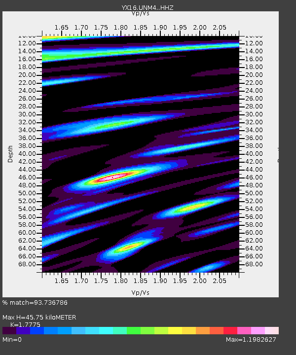
| Estimated Moho Depth: |
45.75 km |
| Estimated Crust Vp/Vs: |
1.78 |
| Assumed Crust Vp: |
6.316 km/s |
| Estimated Crust Vs: |
3.553 km/s |
| Estimated Crust Poisson's Ratio: |
0.27 |
|
| Radial Match: |
93.736786 % |
| Radial Bump: |
360 |
| Transverse Match: |
90.4621 % |
| Transverse Bump: |
400 |
| SOD ConfigId: |
13570011 |
| Insert Time: |
2019-04-30 12:45:40.644 +0000 |
| GWidth: |
2.5 |
| Max Bumps: |
400 |
| Tol: |
0.001 |
|

Signal To Noise
| Channel | StoN | STA | LTA |
| YX:UNM4: :HHZ:20180706T01:50:16.020017Z | 34.429432 | 3.927484E-6 | 1.1407346E-7 |
| YX:UNM4: :HHN:20180706T01:50:16.020017Z | 6.1435933 | 6.8620625E-7 | 1.11694604E-7 |
| YX:UNM4: :HHE:20180706T01:50:16.020017Z | 6.880096 | 6.6555884E-7 | 9.6736855E-8 |
| Arrivals |
| Ps | 5.9 SECOND |
| PpPs | 19 SECOND |
| PsPs/PpSs | 25 SECOND |


