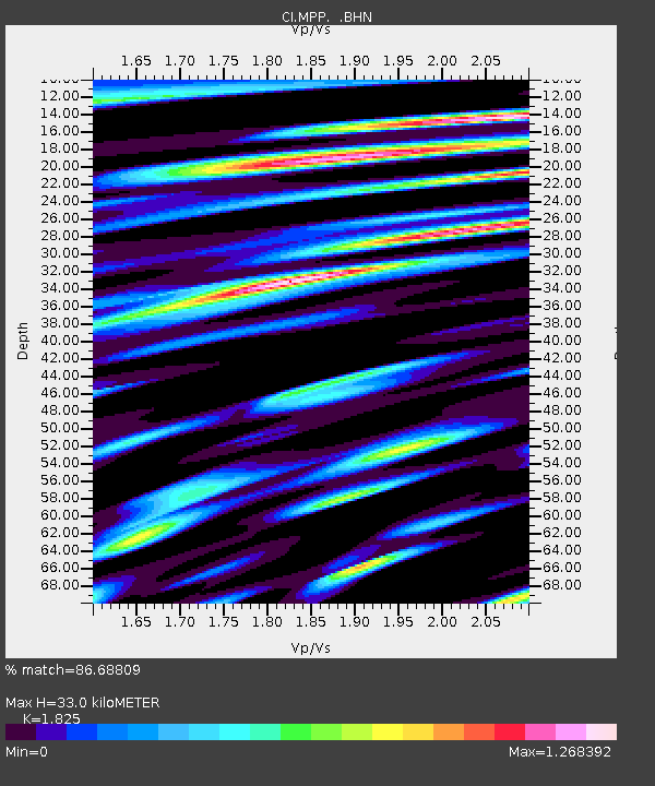
MPP McPhearson Peak - Earthquake Result Viewer
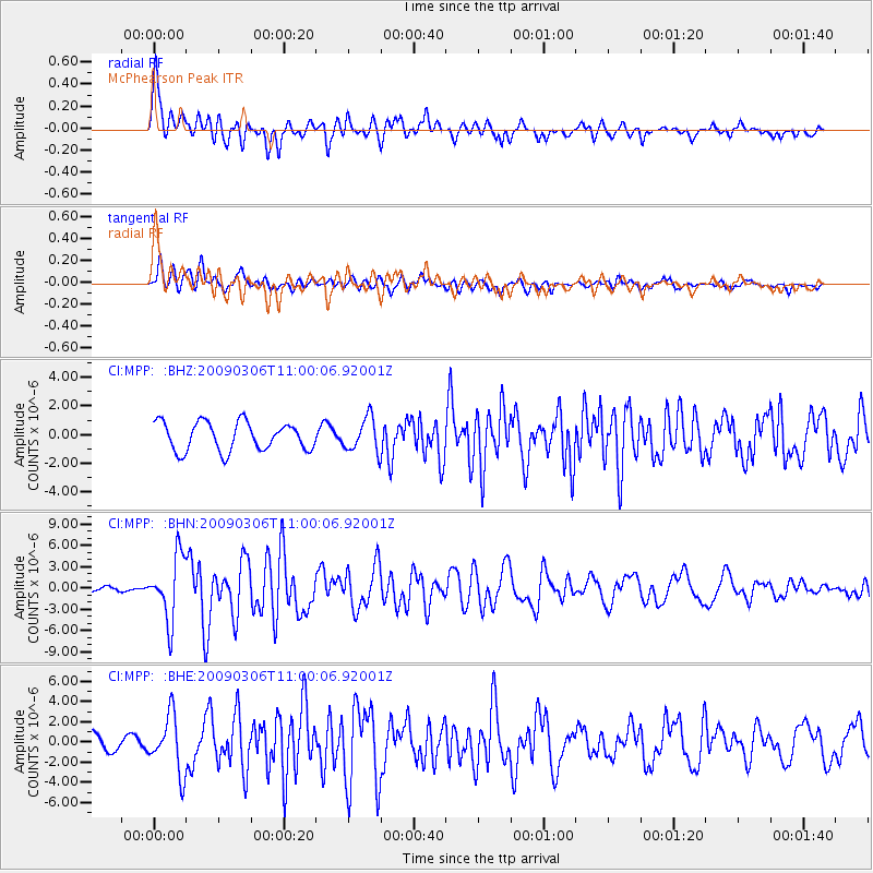
Earthquake location: North Of Svalbard
Earthquake latitude/longitude: 80.3/-1.9
Earthquake time(UTC): 2009/03/06 (065) 10:50:29 GMT
Earthquake Depth: 9.0 km
Earthquake Magnitude: 6.6 MB, 6.5 MS, 6.5 MW, 6.4 MW
Earthquake Catalog/Contributor: WHDF/NEIC
Network: CI Caltech Regional Seismic Network
Station: MPP McPhearson Peak
Lat/Lon: 34.89 N/119.81 W
Elevation: 1739 m
Distance: 60.3 deg
Az: 303.259 deg
Baz: 9.909 deg
Ray Param: 0.06164882
Estimated Moho Depth: 33.0 km
Estimated Crust Vp/Vs: 1.83
Assumed Crust Vp: 6.1 km/s
Estimated Crust Vs: 3.342 km/s
Estimated Crust Poisson's Ratio: 0.29
Radial Match: 86.68809 %
Radial Bump: 400
Transverse Match: 77.467964 %
Transverse Bump: 400
SOD ConfigId: 2658
Insert Time: 2010-02-26 02:04:08.357 +0000
GWidth: 2.5
Max Bumps: 400
Tol: 0.001

Signal To Noise

ChannelStoNSTALTA
CI:MPP: :BHN:20090306T11:00:06.92001Z8.4319214.475003E-65.307217E-7
CI:MPP: :BHE:20090306T11:00:06.92001Z2.37833022.7854117E-61.1711627E-6
CI:MPP: :BHZ:20090306T11:00:06.92001Z1.1941791.1816098E-69.894745E-7
Arrivals
Ps4.6 SECOND
PpPs15 SECOND
PsPs/PpSs19 SECOND