You are here: Home > Network List > TA - USArray Transportable Network (new EarthScope stations) Stations List
> Station R20A Redvale, CO, USA > Earthquake Result Viewer
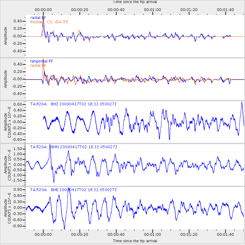
R20A Redvale, CO, USA - Earthquake Result Viewer
*The percent match for this event was below the threshold and hence no stack was calculated.
| Earthquake location: |
Near Coast Of Northern Chile |
| Earthquake latitude/longitude: |
-19.6/-70.5 |
| Earthquake time(UTC): |
2009/04/17 (107) 02:08:08 GMT |
| Earthquake Depth: |
25 km |
| Earthquake Magnitude: |
5.8 MB, 5.8 MS, 6.1 MW, 6.1 MW |
| Earthquake Catalog/Contributor: |
WHDF/NEIC |
|
| Network: |
TA USArray Transportable Network (new EarthScope stations) |
| Station: |
R20A Redvale, CO, USA |
| Lat/Lon: |
38.19 N/108.38 W |
| Elevation: |
2003 m |
|
| Distance: |
67.6 deg |
| Az: |
328.431 deg |
| Baz: |
141.214 deg |
| Ray Param: |
$rayparam |
*The percent match for this event was below the threshold and hence was not used in the summary stack. |
|
| Radial Match: |
79.129135 % |
| Radial Bump: |
371 |
| Transverse Match: |
55.868206 % |
| Transverse Bump: |
400 |
| SOD ConfigId: |
2658 |
| Insert Time: |
2010-03-06 12:27:37.469 +0000 |
| GWidth: |
2.5 |
| Max Bumps: |
400 |
| Tol: |
0.001 |
|
Signal To Noise
| Channel | StoN | STA | LTA |
| TA:R20A: :BHN:20090417T02:18:32.050027Z | 3.5534306 | 6.8870344E-7 | 1.9381366E-7 |
| TA:R20A: :BHE:20090417T02:18:32.050027Z | 1.6612247 | 2.360314E-7 | 1.4208277E-7 |
| TA:R20A: :BHZ:20090417T02:18:32.050027Z | 1.1871706 | 2.1449888E-7 | 1.8068076E-7 |
| Arrivals |
| Ps | |
| PpPs | |
| PsPs/PpSs | |


