You are here: Home > Network List > TA - USArray Transportable Network (new EarthScope stations) Stations List
> Station R20A Redvale, CO, USA > Earthquake Result Viewer
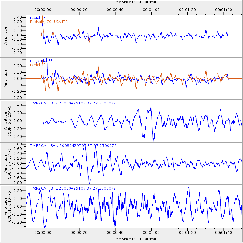
R20A Redvale, CO, USA - Earthquake Result Viewer
*The percent match for this event was below the threshold and hence no stack was calculated.
| Earthquake location: |
Hokkaido, Japan Region |
| Earthquake latitude/longitude: |
41.5/142.0 |
| Earthquake time(UTC): |
2008/04/29 (120) 05:26:04 GMT |
| Earthquake Depth: |
47 km |
| Earthquake Magnitude: |
5.5 MB, 5.2 MS, 5.8 MW, 5.8 MW |
| Earthquake Catalog/Contributor: |
WHDF/NEIC |
|
| Network: |
TA USArray Transportable Network (new EarthScope stations) |
| Station: |
R20A Redvale, CO, USA |
| Lat/Lon: |
38.19 N/108.38 W |
| Elevation: |
2003 m |
|
| Distance: |
78.0 deg |
| Az: |
49.366 deg |
| Baz: |
313.619 deg |
| Ray Param: |
$rayparam |
*The percent match for this event was below the threshold and hence was not used in the summary stack. |
|
| Radial Match: |
60.855602 % |
| Radial Bump: |
400 |
| Transverse Match: |
70.65722 % |
| Transverse Bump: |
400 |
| SOD ConfigId: |
2504 |
| Insert Time: |
2010-03-06 12:27:47.664 +0000 |
| GWidth: |
2.5 |
| Max Bumps: |
400 |
| Tol: |
0.001 |
|
Signal To Noise
| Channel | StoN | STA | LTA |
| TA:R20A: :BHN:20080429T05:37:27.250007Z | 2.4338946 | 2.2698185E-7 | 9.3258706E-8 |
| TA:R20A: :BHE:20080429T05:37:27.250007Z | 1.5778776 | 1.6364358E-7 | 1.03711194E-7 |
| TA:R20A: :BHZ:20080429T05:37:27.250007Z | 1.9664494 | 1.231261E-7 | 6.261341E-8 |
| Arrivals |
| Ps | |
| PpPs | |
| PsPs/PpSs | |


