You are here: Home > Network List > AV - Alaska Volcano Observatory Stations List
> Station WAZA Wrangell Zanetti, Alaska > Earthquake Result Viewer
WAZA Wrangell Zanetti, Alaska - Earthquake Result Viewer
| Earthquake location: |
Near East Coast Of Honshu, Japan |
| Earthquake latitude/longitude: |
35.1/140.7 |
| Earthquake time(UTC): |
2018/07/07 (188) 11:23:49 GMT |
| Earthquake Depth: |
39 km |
| Earthquake Magnitude: |
5.9 Mww |
| Earthquake Catalog/Contributor: |
NEIC PDE/us |
|
| Network: |
AV Alaska Volcano Observatory |
| Station: |
WAZA Wrangell Zanetti, Alaska |
| Lat/Lon: |
62.07 N/144.15 W |
| Elevation: |
2531 m |
|
| Distance: |
52.9 deg |
| Az: |
34.81 deg |
| Baz: |
276.085 deg |
| Ray Param: |
0.06639302 |
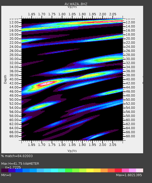
| Estimated Moho Depth: |
41.75 km |
| Estimated Crust Vp/Vs: |
1.72 |
| Assumed Crust Vp: |
6.566 km/s |
| Estimated Crust Vs: |
3.812 km/s |
| Estimated Crust Poisson's Ratio: |
0.25 |
|
| Radial Match: |
84.82003 % |
| Radial Bump: |
400 |
| Transverse Match: |
74.704475 % |
| Transverse Bump: |
400 |
| SOD ConfigId: |
13570011 |
| Insert Time: |
2019-04-30 12:50:14.347 +0000 |
| GWidth: |
2.5 |
| Max Bumps: |
400 |
| Tol: |
0.001 |
|

Signal To Noise
| Channel | StoN | STA | LTA |
| AV:WAZA: :BHZ:20180707T11:32:31.19998Z | 16.883902 | 9.940167E-7 | 5.887364E-8 |
| AV:WAZA: :BHN:20180707T11:32:31.19998Z | 2.3007665 | 1.9516865E-7 | 8.482767E-8 |
| AV:WAZA: :BHE:20180707T11:32:31.19998Z | 4.2281127 | 2.548751E-7 | 6.028105E-8 |
| Arrivals |
| Ps | 4.9 SECOND |
| PpPs | 16 SECOND |
| PsPs/PpSs | 21 SECOND |


