You are here: Home > Network List > CI - Caltech Regional Seismic Network Stations List
> Station MPM Manuel Prospect Mine, California, USA > Earthquake Result Viewer
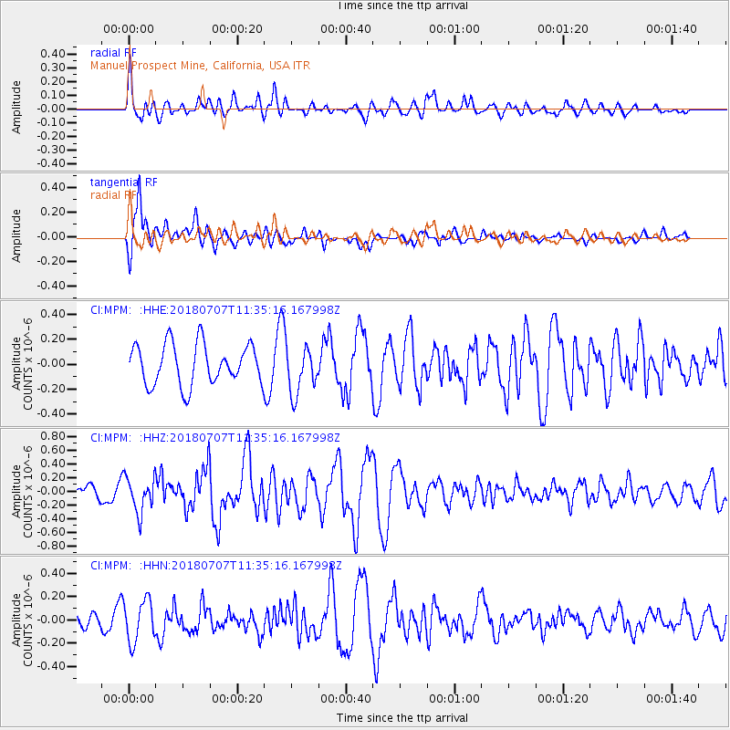
MPM Manuel Prospect Mine, California, USA - Earthquake Result Viewer
*The percent match for this event was below the threshold and hence no stack was calculated.
| Earthquake location: |
Near East Coast Of Honshu, Japan |
| Earthquake latitude/longitude: |
35.1/140.7 |
| Earthquake time(UTC): |
2018/07/07 (188) 11:23:49 GMT |
| Earthquake Depth: |
39 km |
| Earthquake Magnitude: |
5.9 Mww |
| Earthquake Catalog/Contributor: |
NEIC PDE/us |
|
| Network: |
CI Caltech Regional Seismic Network |
| Station: |
MPM Manuel Prospect Mine, California, USA |
| Lat/Lon: |
36.06 N/117.49 W |
| Elevation: |
185 m |
|
| Distance: |
78.5 deg |
| Az: |
54.015 deg |
| Baz: |
305.025 deg |
| Ray Param: |
$rayparam |
*The percent match for this event was below the threshold and hence was not used in the summary stack. |
|
| Radial Match: |
67.781525 % |
| Radial Bump: |
400 |
| Transverse Match: |
66.34938 % |
| Transverse Bump: |
400 |
| SOD ConfigId: |
13570011 |
| Insert Time: |
2019-04-30 12:51:14.709 +0000 |
| GWidth: |
2.5 |
| Max Bumps: |
400 |
| Tol: |
0.001 |
|
Signal To Noise
| Channel | StoN | STA | LTA |
| CI:MPM: :HHZ:20180707T11:35:16.167998Z | 3.1055973 | 2.5791928E-7 | 8.304982E-8 |
| CI:MPM: :HHN:20180707T11:35:16.167998Z | 1.4207411 | 1.8024947E-7 | 1.2687003E-7 |
| CI:MPM: :HHE:20180707T11:35:16.167998Z | 1.2260481 | 1.9732198E-7 | 1.6094147E-7 |
| Arrivals |
| Ps | |
| PpPs | |
| PsPs/PpSs | |


