You are here: Home > Network List > TA - USArray Transportable Network (new EarthScope stations) Stations List
> Station R20A Redvale, CO, USA > Earthquake Result Viewer
R20A Redvale, CO, USA - Earthquake Result Viewer
*The percent match for this event was below the threshold and hence no stack was calculated.
| Earthquake location: |
Rat Islands, Aleutian Islands |
| Earthquake latitude/longitude: |
52.2/178.1 |
| Earthquake time(UTC): |
2009/10/07 (280) 05:38:37 GMT |
| Earthquake Depth: |
138 km |
| Earthquake Magnitude: |
5.6 MB, 5.6 MW, 5.6 MW |
| Earthquake Catalog/Contributor: |
WHDF/NEIC |
|
| Network: |
TA USArray Transportable Network (new EarthScope stations) |
| Station: |
R20A Redvale, CO, USA |
| Lat/Lon: |
38.19 N/108.38 W |
| Elevation: |
2003 m |
|
| Distance: |
51.5 deg |
| Az: |
74.914 deg |
| Baz: |
310.985 deg |
| Ray Param: |
$rayparam |
*The percent match for this event was below the threshold and hence was not used in the summary stack. |
|
| Radial Match: |
55.298584 % |
| Radial Bump: |
400 |
| Transverse Match: |
58.672497 % |
| Transverse Bump: |
400 |
| SOD ConfigId: |
2622 |
| Insert Time: |
2010-03-06 12:28:25.219 +0000 |
| GWidth: |
2.5 |
| Max Bumps: |
400 |
| Tol: |
0.001 |
|
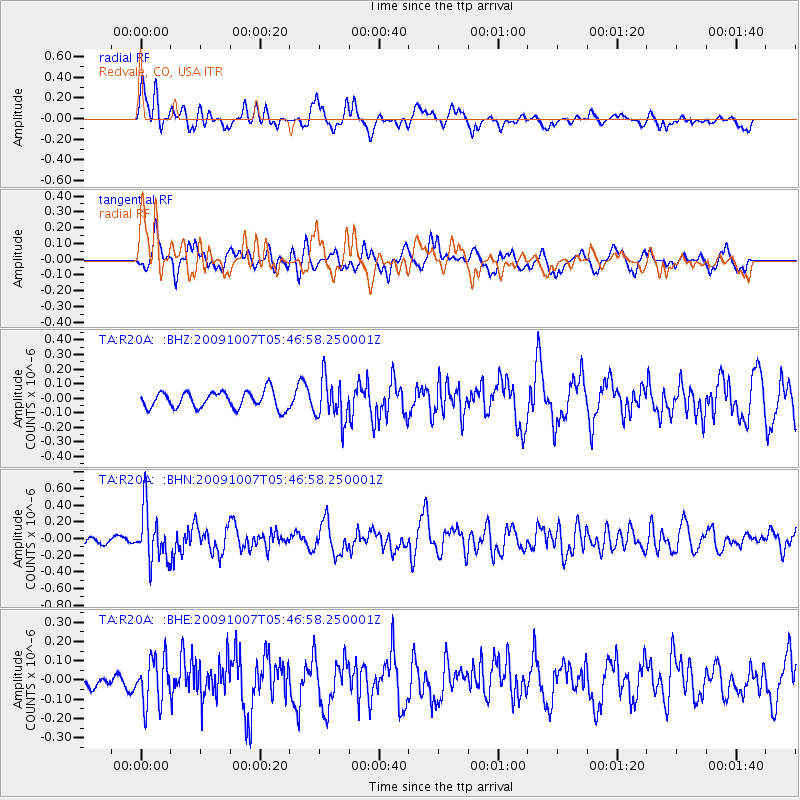
Signal To Noise
| Channel | StoN | STA | LTA |
| TA:R20A: :BHN:20091007T05:46:58.250001Z | 4.0709405 | 3.0975735E-7 | 7.6089876E-8 |
| TA:R20A: :BHE:20091007T05:46:58.250001Z | 1.658523 | 1.218002E-7 | 7.343896E-8 |
| TA:R20A: :BHZ:20091007T05:46:58.250001Z | 2.4482114 | 1.4193512E-7 | 5.7975022E-8 |
| Arrivals |
| Ps | |
| PpPs | |
| PsPs/PpSs | |


