You are here: Home > Network List > TA - USArray Transportable Network (new EarthScope stations) Stations List
> Station R20A Redvale, CO, USA > Earthquake Result Viewer
R20A Redvale, CO, USA - Earthquake Result Viewer
*The percent match for this event was below the threshold and hence no stack was calculated.
| Earthquake location: |
South Of Tonga Islands |
| Earthquake latitude/longitude: |
-24.1/-175.2 |
| Earthquake time(UTC): |
2009/11/02 (306) 10:47:13 GMT |
| Earthquake Depth: |
9.0 km |
| Earthquake Magnitude: |
6.1 MB, 6.1 MS, 6.2 MW, 6.1 MW |
| Earthquake Catalog/Contributor: |
WHDF/NEIC |
|
| Network: |
TA USArray Transportable Network (new EarthScope stations) |
| Station: |
R20A Redvale, CO, USA |
| Lat/Lon: |
38.19 N/108.38 W |
| Elevation: |
2003 m |
|
| Distance: |
88.1 deg |
| Az: |
46.439 deg |
| Baz: |
237.166 deg |
| Ray Param: |
$rayparam |
*The percent match for this event was below the threshold and hence was not used in the summary stack. |
|
| Radial Match: |
78.14334 % |
| Radial Bump: |
385 |
| Transverse Match: |
72.57651 % |
| Transverse Bump: |
400 |
| SOD ConfigId: |
2622 |
| Insert Time: |
2010-03-06 12:28:31.927 +0000 |
| GWidth: |
2.5 |
| Max Bumps: |
400 |
| Tol: |
0.001 |
|
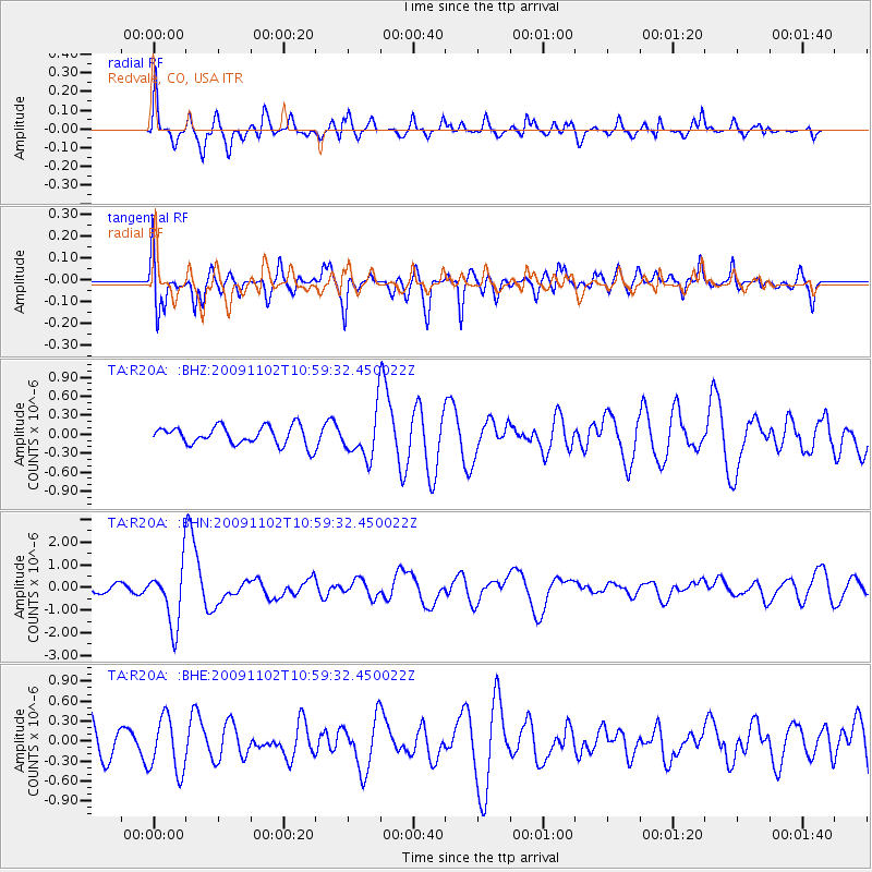
Signal To Noise
| Channel | StoN | STA | LTA |
| TA:R20A: :BHN:20091102T10:59:32.450022Z | 7.1191597 | 1.3184011E-6 | 1.8519056E-7 |
| TA:R20A: :BHE:20091102T10:59:32.450022Z | 1.9495988 | 4.1170154E-7 | 2.1117243E-7 |
| TA:R20A: :BHZ:20091102T10:59:32.450022Z | 2.479325 | 3.6254445E-7 | 1.4622708E-7 |
| Arrivals |
| Ps | |
| PpPs | |
| PsPs/PpSs | |


