You are here: Home > Network List > CI - Caltech Regional Seismic Network Stations List
> Station MPP McPhearson Peak > Earthquake Result Viewer
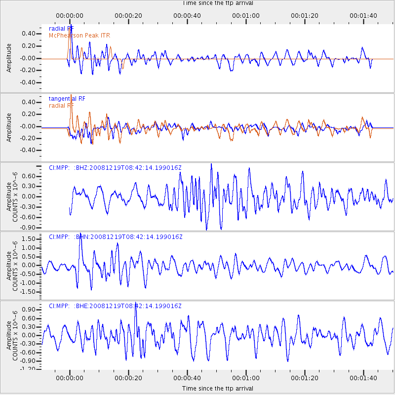
MPP McPhearson Peak - Earthquake Result Viewer
*The percent match for this event was below the threshold and hence no stack was calculated.
| Earthquake location: |
Northern Mid-Atlantic Ridge |
| Earthquake latitude/longitude: |
47.0/-27.3 |
| Earthquake time(UTC): |
2008/12/19 (354) 08:31:51 GMT |
| Earthquake Depth: |
2.0 km |
| Earthquake Magnitude: |
5.8 MB, 5.6 MS, 5.9 MW, 5.8 MW |
| Earthquake Catalog/Contributor: |
WHDF/NEIC |
|
| Network: |
CI Caltech Regional Seismic Network |
| Station: |
MPP McPhearson Peak |
| Lat/Lon: |
34.89 N/119.81 W |
| Elevation: |
1739 m |
|
| Distance: |
67.0 deg |
| Az: |
296.87 deg |
| Baz: |
47.961 deg |
| Ray Param: |
$rayparam |
*The percent match for this event was below the threshold and hence was not used in the summary stack. |
|
| Radial Match: |
71.35288 % |
| Radial Bump: |
400 |
| Transverse Match: |
50.577576 % |
| Transverse Bump: |
400 |
| SOD ConfigId: |
2658 |
| Insert Time: |
2010-02-26 02:04:16.228 +0000 |
| GWidth: |
2.5 |
| Max Bumps: |
400 |
| Tol: |
0.001 |
|
Signal To Noise
| Channel | StoN | STA | LTA |
| CI:MPP: :BHN:20081219T08:42:14.199016Z | 4.092783 | 7.578057E-7 | 1.851566E-7 |
| CI:MPP: :BHE:20081219T08:42:14.199016Z | 1.456029 | 2.7714214E-7 | 1.9034108E-7 |
| CI:MPP: :BHZ:20081219T08:42:14.199016Z | 1.0698942 | 2.2294081E-7 | 2.083765E-7 |
| Arrivals |
| Ps | |
| PpPs | |
| PsPs/PpSs | |


