You are here: Home > Network List > TA - USArray Transportable Network (new EarthScope stations) Stations List
> Station R20A Redvale, CO, USA > Earthquake Result Viewer
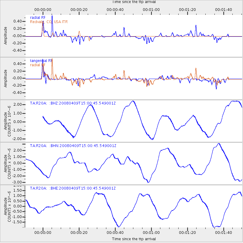
R20A Redvale, CO, USA - Earthquake Result Viewer
*The percent match for this event was below the threshold and hence no stack was calculated.
| Earthquake location: |
Vanuatu Islands |
| Earthquake latitude/longitude: |
-20.0/168.9 |
| Earthquake time(UTC): |
2008/04/09 (100) 14:47:50 GMT |
| Earthquake Depth: |
35 km |
| Earthquake Magnitude: |
5.9 MB, 6.2 MS, 6.3 MW |
| Earthquake Catalog/Contributor: |
WHDF/NEIC |
|
| Network: |
TA USArray Transportable Network (new EarthScope stations) |
| Station: |
R20A Redvale, CO, USA |
| Lat/Lon: |
38.19 N/108.38 W |
| Elevation: |
2003 m |
|
| Distance: |
96.6 deg |
| Az: |
51.904 deg |
| Baz: |
249.923 deg |
| Ray Param: |
$rayparam |
*The percent match for this event was below the threshold and hence was not used in the summary stack. |
|
| Radial Match: |
85.583405 % |
| Radial Bump: |
335 |
| Transverse Match: |
80.65994 % |
| Transverse Bump: |
400 |
| SOD ConfigId: |
2504 |
| Insert Time: |
2010-03-06 12:28:57.115 +0000 |
| GWidth: |
2.5 |
| Max Bumps: |
400 |
| Tol: |
0.001 |
|
Signal To Noise
| Channel | StoN | STA | LTA |
| TA:R20A: :BHN:20080409T15:00:45.549001Z | 2.2838957 | 2.0266004E-6 | 8.873437E-7 |
| TA:R20A: :BHE:20080409T15:00:45.549001Z | 0.5916844 | 1.821343E-7 | 3.078234E-7 |
| TA:R20A: :BHZ:20080409T15:00:45.549001Z | 1.1027905 | 8.996024E-7 | 8.1575104E-7 |
| Arrivals |
| Ps | |
| PpPs | |
| PsPs/PpSs | |


