You are here: Home > Network List > CI - Caltech Regional Seismic Network Stations List
> Station MPP McPhearson Peak > Earthquake Result Viewer
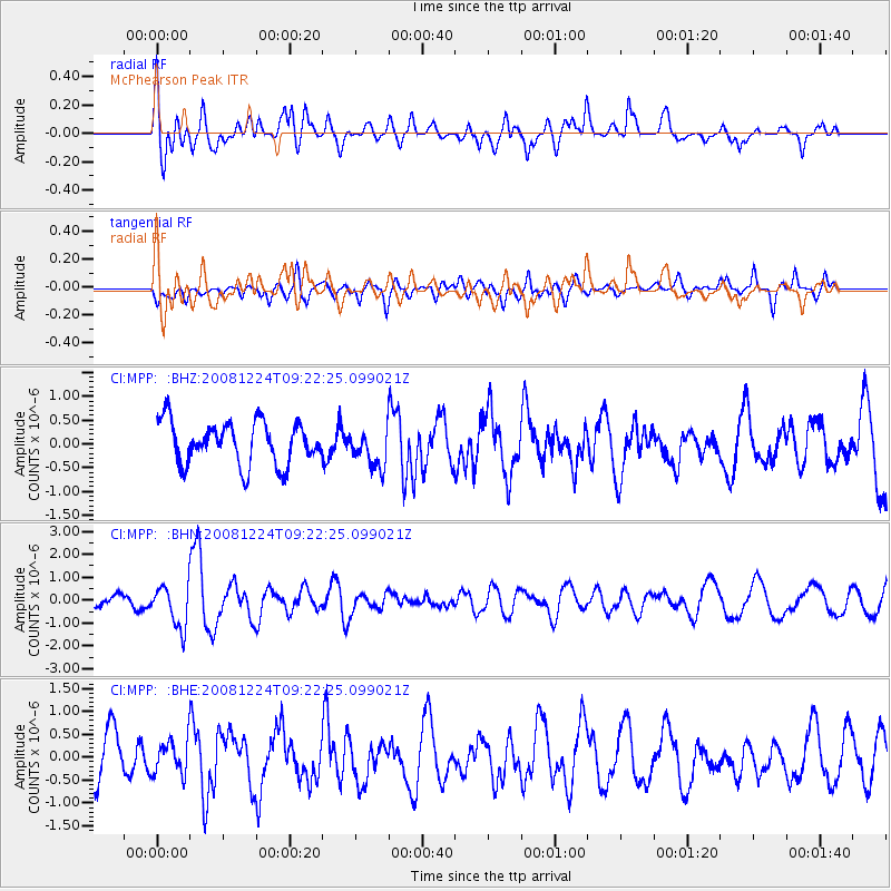
MPP McPhearson Peak - Earthquake Result Viewer
*The percent match for this event was below the threshold and hence no stack was calculated.
| Earthquake location: |
Tonga Islands Region |
| Earthquake latitude/longitude: |
-17.3/-171.9 |
| Earthquake time(UTC): |
2008/12/24 (359) 09:11:34 GMT |
| Earthquake Depth: |
9.0 km |
| Earthquake Magnitude: |
5.9 MB, 5.6 MS, 6.0 MW, 6.0 MW |
| Earthquake Catalog/Contributor: |
WHDF/NEIC |
|
| Network: |
CI Caltech Regional Seismic Network |
| Station: |
MPP McPhearson Peak |
| Lat/Lon: |
34.89 N/119.81 W |
| Elevation: |
1739 m |
|
| Distance: |
71.7 deg |
| Az: |
43.099 deg |
| Baz: |
232.567 deg |
| Ray Param: |
$rayparam |
*The percent match for this event was below the threshold and hence was not used in the summary stack. |
|
| Radial Match: |
64.33353 % |
| Radial Bump: |
400 |
| Transverse Match: |
46.326733 % |
| Transverse Bump: |
400 |
| SOD ConfigId: |
2658 |
| Insert Time: |
2010-02-26 02:04:18.618 +0000 |
| GWidth: |
2.5 |
| Max Bumps: |
400 |
| Tol: |
0.001 |
|
Signal To Noise
| Channel | StoN | STA | LTA |
| CI:MPP: :BHN:20081224T09:22:25.099021Z | 3.676834 | 9.1829077E-7 | 2.497504E-7 |
| CI:MPP: :BHE:20081224T09:22:25.099021Z | 0.72137725 | 3.6975717E-7 | 5.125712E-7 |
| CI:MPP: :BHZ:20081224T09:22:25.099021Z | 0.9064825 | 4.0571086E-7 | 4.4756612E-7 |
| Arrivals |
| Ps | |
| PpPs | |
| PsPs/PpSs | |


