You are here: Home > Network List > TA - USArray Transportable Network (new EarthScope stations) Stations List
> Station R20A Redvale, CO, USA > Earthquake Result Viewer
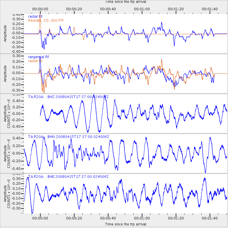
R20A Redvale, CO, USA - Earthquake Result Viewer
*The percent match for this event was below the threshold and hence no stack was calculated.
| Earthquake location: |
Tonga Islands |
| Earthquake latitude/longitude: |
-18.7/-176.0 |
| Earthquake time(UTC): |
2008/04/15 (106) 17:24:56 GMT |
| Earthquake Depth: |
10 km |
| Earthquake Magnitude: |
5.5 MB, 5.5 MS, 5.7 MW, 5.6 MW |
| Earthquake Catalog/Contributor: |
WHDF/NEIC |
|
| Network: |
TA USArray Transportable Network (new EarthScope stations) |
| Station: |
R20A Redvale, CO, USA |
| Lat/Lon: |
38.19 N/108.38 W |
| Elevation: |
2003 m |
|
| Distance: |
84.9 deg |
| Az: |
46.996 deg |
| Baz: |
241.606 deg |
| Ray Param: |
$rayparam |
*The percent match for this event was below the threshold and hence was not used in the summary stack. |
|
| Radial Match: |
59.921227 % |
| Radial Bump: |
400 |
| Transverse Match: |
27.984241 % |
| Transverse Bump: |
400 |
| SOD ConfigId: |
2504 |
| Insert Time: |
2010-03-06 12:28:58.343 +0000 |
| GWidth: |
2.5 |
| Max Bumps: |
400 |
| Tol: |
0.001 |
|
Signal To Noise
| Channel | StoN | STA | LTA |
| TA:R20A: :BHN:20080415T17:37:00.024006Z | 2.2673893 | 2.9562673E-7 | 1.3038199E-7 |
| TA:R20A: :BHE:20080415T17:37:00.024006Z | 0.52628136 | 1.00742014E-7 | 1.9142234E-7 |
| TA:R20A: :BHZ:20080415T17:37:00.024006Z | 2.1636097 | 3.9030724E-7 | 1.8039631E-7 |
| Arrivals |
| Ps | |
| PpPs | |
| PsPs/PpSs | |


