You are here: Home > Network List > TA - USArray Transportable Network (new EarthScope stations) Stations List
> Station R20A Redvale, CO, USA > Earthquake Result Viewer
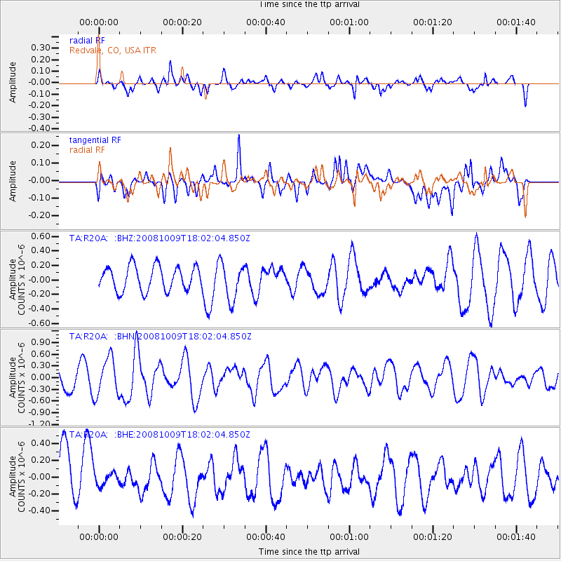
R20A Redvale, CO, USA - Earthquake Result Viewer
*The percent match for this event was below the threshold and hence no stack was calculated.
| Earthquake location: |
Tonga Islands |
| Earthquake latitude/longitude: |
-21.0/-174.4 |
| Earthquake time(UTC): |
2008/10/09 (283) 17:49:58 GMT |
| Earthquake Depth: |
10 km |
| Earthquake Magnitude: |
5.8 MB, 5.6 MS, 5.9 MW, 5.9 MW |
| Earthquake Catalog/Contributor: |
WHDF/NEIC |
|
| Network: |
TA USArray Transportable Network (new EarthScope stations) |
| Station: |
R20A Redvale, CO, USA |
| Lat/Lon: |
38.19 N/108.38 W |
| Elevation: |
2003 m |
|
| Distance: |
85.5 deg |
| Az: |
46.25 deg |
| Baz: |
238.914 deg |
| Ray Param: |
$rayparam |
*The percent match for this event was below the threshold and hence was not used in the summary stack. |
|
| Radial Match: |
43.312218 % |
| Radial Bump: |
385 |
| Transverse Match: |
53.197887 % |
| Transverse Bump: |
400 |
| SOD ConfigId: |
2556 |
| Insert Time: |
2010-03-06 12:29:09.917 +0000 |
| GWidth: |
2.5 |
| Max Bumps: |
400 |
| Tol: |
0.001 |
|
Signal To Noise
| Channel | StoN | STA | LTA |
| TA:R20A: :BHN:20081009T18:02:04.850Z | 1.6357145 | 4.8067653E-7 | 2.9386334E-7 |
| TA:R20A: :BHE:20081009T18:02:04.850Z | 0.29865316 | 7.4555146E-8 | 2.496379E-7 |
| TA:R20A: :BHZ:20081009T18:02:04.850Z | 1.5271219 | 2.5456703E-7 | 1.6669726E-7 |
| Arrivals |
| Ps | |
| PpPs | |
| PsPs/PpSs | |


