You are here: Home > Network List > TA - USArray Transportable Network (new EarthScope stations) Stations List
> Station A36M Sachs Harbour, NT, CAN > Earthquake Result Viewer
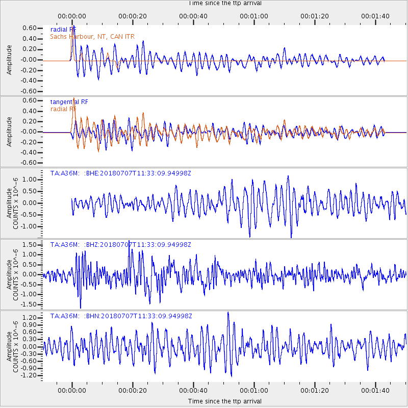
A36M Sachs Harbour, NT, CAN - Earthquake Result Viewer
*The percent match for this event was below the threshold and hence no stack was calculated.
| Earthquake location: |
Near East Coast Of Honshu, Japan |
| Earthquake latitude/longitude: |
35.1/140.7 |
| Earthquake time(UTC): |
2018/07/07 (188) 11:23:49 GMT |
| Earthquake Depth: |
39 km |
| Earthquake Magnitude: |
5.9 Mww |
| Earthquake Catalog/Contributor: |
NEIC PDE/us |
|
| Network: |
TA USArray Transportable Network (new EarthScope stations) |
| Station: |
A36M Sachs Harbour, NT, CAN |
| Lat/Lon: |
71.99 N/125.25 W |
| Elevation: |
32 m |
|
| Distance: |
58.3 deg |
| Az: |
21.394 deg |
| Baz: |
285.949 deg |
| Ray Param: |
$rayparam |
*The percent match for this event was below the threshold and hence was not used in the summary stack. |
|
| Radial Match: |
77.928185 % |
| Radial Bump: |
400 |
| Transverse Match: |
66.84376 % |
| Transverse Bump: |
400 |
| SOD ConfigId: |
13570011 |
| Insert Time: |
2019-04-30 12:56:27.387 +0000 |
| GWidth: |
2.5 |
| Max Bumps: |
400 |
| Tol: |
0.001 |
|
Signal To Noise
| Channel | StoN | STA | LTA |
| TA:A36M: :BHZ:20180707T11:33:09.94998Z | 4.29554 | 7.0122303E-7 | 1.6324445E-7 |
| TA:A36M: :BHN:20180707T11:33:09.94998Z | 1.757673 | 3.8373184E-7 | 2.183181E-7 |
| TA:A36M: :BHE:20180707T11:33:09.94998Z | 1.7029005 | 3.7759006E-7 | 2.2173347E-7 |
| Arrivals |
| Ps | |
| PpPs | |
| PsPs/PpSs | |


