You are here: Home > Network List > TA - USArray Transportable Network (new EarthScope stations) Stations List
> Station B18K Kokolik River, AK, USA > Earthquake Result Viewer
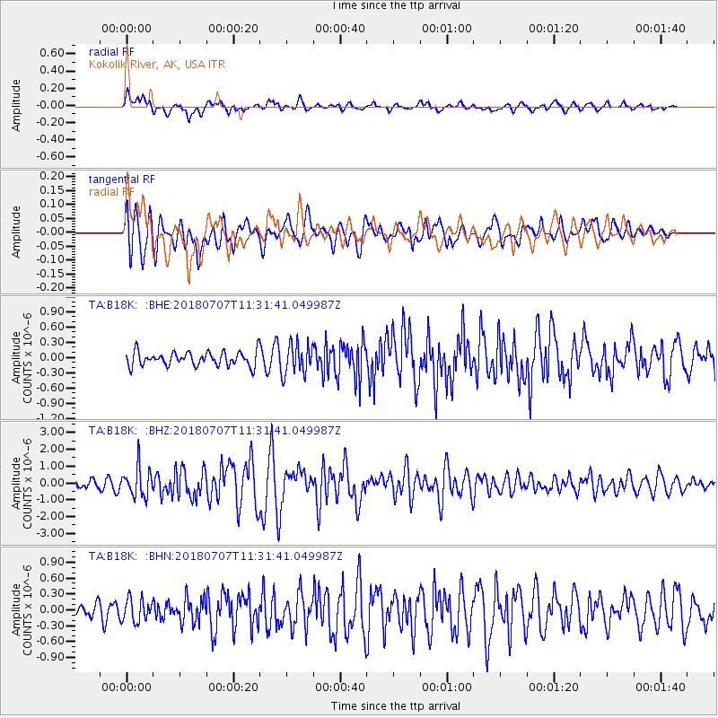
B18K Kokolik River, AK, USA - Earthquake Result Viewer
*The percent match for this event was below the threshold and hence no stack was calculated.
| Earthquake location: |
Near East Coast Of Honshu, Japan |
| Earthquake latitude/longitude: |
35.1/140.7 |
| Earthquake time(UTC): |
2018/07/07 (188) 11:23:49 GMT |
| Earthquake Depth: |
39 km |
| Earthquake Magnitude: |
5.9 Mww |
| Earthquake Catalog/Contributor: |
NEIC PDE/us |
|
| Network: |
TA USArray Transportable Network (new EarthScope stations) |
| Station: |
B18K Kokolik River, AK, USA |
| Lat/Lon: |
69.36 N/161.80 W |
| Elevation: |
222 m |
|
| Distance: |
46.3 deg |
| Az: |
24.45 deg |
| Baz: |
253.223 deg |
| Ray Param: |
$rayparam |
*The percent match for this event was below the threshold and hence was not used in the summary stack. |
|
| Radial Match: |
71.43547 % |
| Radial Bump: |
400 |
| Transverse Match: |
73.94898 % |
| Transverse Bump: |
400 |
| SOD ConfigId: |
13570011 |
| Insert Time: |
2019-04-30 12:56:27.774 +0000 |
| GWidth: |
2.5 |
| Max Bumps: |
400 |
| Tol: |
0.001 |
|
Signal To Noise
| Channel | StoN | STA | LTA |
| TA:B18K: :BHZ:20180707T11:31:41.049987Z | 3.4185133 | 8.846728E-7 | 2.5878876E-7 |
| TA:B18K: :BHN:20180707T11:31:41.049987Z | 1.5635672 | 2.1666708E-7 | 1.3857228E-7 |
| TA:B18K: :BHE:20180707T11:31:41.049987Z | 2.2060907 | 2.9954404E-7 | 1.3578047E-7 |
| Arrivals |
| Ps | |
| PpPs | |
| PsPs/PpSs | |


