You are here: Home > Network List > TA - USArray Transportable Network (new EarthScope stations) Stations List
> Station E18K Tukpahlearik Creek, AK, USA > Earthquake Result Viewer
E18K Tukpahlearik Creek, AK, USA - Earthquake Result Viewer
| Earthquake location: |
Near East Coast Of Honshu, Japan |
| Earthquake latitude/longitude: |
35.1/140.7 |
| Earthquake time(UTC): |
2018/07/07 (188) 11:23:49 GMT |
| Earthquake Depth: |
39 km |
| Earthquake Magnitude: |
5.9 Mww |
| Earthquake Catalog/Contributor: |
NEIC PDE/us |
|
| Network: |
TA USArray Transportable Network (new EarthScope stations) |
| Station: |
E18K Tukpahlearik Creek, AK, USA |
| Lat/Lon: |
67.42 N/160.60 W |
| Elevation: |
297 m |
|
| Distance: |
46.2 deg |
| Az: |
27.22 deg |
| Baz: |
256.253 deg |
| Ray Param: |
0.07070938 |
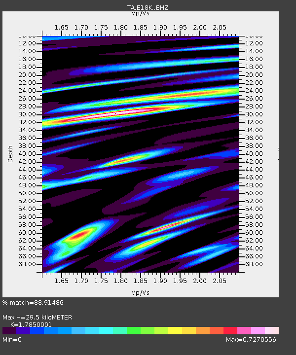
| Estimated Moho Depth: |
29.5 km |
| Estimated Crust Vp/Vs: |
1.79 |
| Assumed Crust Vp: |
6.276 km/s |
| Estimated Crust Vs: |
3.516 km/s |
| Estimated Crust Poisson's Ratio: |
0.27 |
|
| Radial Match: |
88.91486 % |
| Radial Bump: |
400 |
| Transverse Match: |
80.54439 % |
| Transverse Bump: |
400 |
| SOD ConfigId: |
13570011 |
| Insert Time: |
2019-04-30 12:56:47.401 +0000 |
| GWidth: |
2.5 |
| Max Bumps: |
400 |
| Tol: |
0.001 |
|
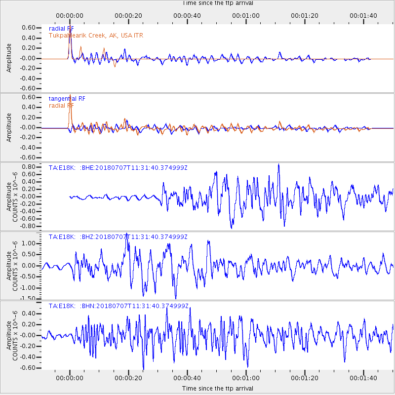
Signal To Noise
| Channel | StoN | STA | LTA |
| TA:E18K: :BHZ:20180707T11:31:40.374999Z | 6.158852 | 3.2042126E-7 | 5.2026135E-8 |
| TA:E18K: :BHN:20180707T11:31:40.374999Z | 1.9794796 | 8.535236E-8 | 4.311859E-8 |
| TA:E18K: :BHE:20180707T11:31:40.374999Z | 4.6202006 | 1.6493718E-7 | 3.5699138E-8 |
| Arrivals |
| Ps | 3.9 SECOND |
| PpPs | 12 SECOND |
| PsPs/PpSs | 16 SECOND |


