You are here: Home > Network List > TA - USArray Transportable Network (new EarthScope stations) Stations List
> Station R20A Redvale, CO, USA > Earthquake Result Viewer
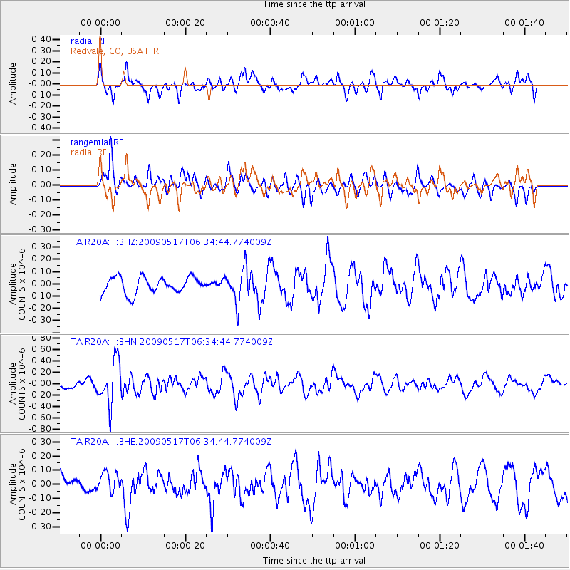
R20A Redvale, CO, USA - Earthquake Result Viewer
*The percent match for this event was below the threshold and hence no stack was calculated.
| Earthquake location: |
Tonga Islands |
| Earthquake latitude/longitude: |
-16.8/-173.5 |
| Earthquake time(UTC): |
2009/05/17 (137) 06:23:03 GMT |
| Earthquake Depth: |
67 km |
| Earthquake Magnitude: |
5.5 MB, 5.6 MW, 5.6 MW |
| Earthquake Catalog/Contributor: |
WHDF/NEIC |
|
| Network: |
TA USArray Transportable Network (new EarthScope stations) |
| Station: |
R20A Redvale, CO, USA |
| Lat/Lon: |
38.19 N/108.38 W |
| Elevation: |
2003 m |
|
| Distance: |
81.9 deg |
| Az: |
46.217 deg |
| Baz: |
241.341 deg |
| Ray Param: |
$rayparam |
*The percent match for this event was below the threshold and hence was not used in the summary stack. |
|
| Radial Match: |
61.550766 % |
| Radial Bump: |
400 |
| Transverse Match: |
58.187275 % |
| Transverse Bump: |
400 |
| SOD ConfigId: |
2760 |
| Insert Time: |
2010-03-06 12:29:19.825 +0000 |
| GWidth: |
2.5 |
| Max Bumps: |
400 |
| Tol: |
0.001 |
|
Signal To Noise
| Channel | StoN | STA | LTA |
| TA:R20A: :BHN:20090517T06:34:44.774009Z | 2.8911896 | 3.863029E-7 | 1.3361382E-7 |
| TA:R20A: :BHE:20090517T06:34:44.774009Z | 0.6531131 | 6.899944E-8 | 1.05647E-7 |
| TA:R20A: :BHZ:20090517T06:34:44.774009Z | 2.1236026 | 1.3767212E-7 | 6.482951E-8 |
| Arrivals |
| Ps | |
| PpPs | |
| PsPs/PpSs | |


