You are here: Home > Network List > TA - USArray Transportable Network (new EarthScope stations) Stations List
> Station G21K Allakaket, AK, USA > Earthquake Result Viewer
G21K Allakaket, AK, USA - Earthquake Result Viewer
| Earthquake location: |
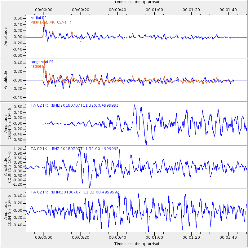
Near East Coast Of Honshu, Japan |
| Earthquake latitude/longitude: |
35.1/140.7 |
| Earthquake time(UTC): |
2018/07/07 (188) 11:23:49 GMT |
| Earthquake Depth: |
39 km |
| Earthquake Magnitude: |
5.9 Mww |
| Earthquake Catalog/Contributor: |
NEIC PDE/us |
|
| Network: |
TA USArray Transportable Network (new EarthScope stations) |
| Station: |
G21K Allakaket, AK, USA |
| Lat/Lon: |
66.52 N/153.51 W |
| Elevation: |
446 m |
|
| Distance: |
48.8 deg |
| Az: |
29.082 deg |
| Baz: |
264.037 deg |
| Ray Param: |
0.06903771 |
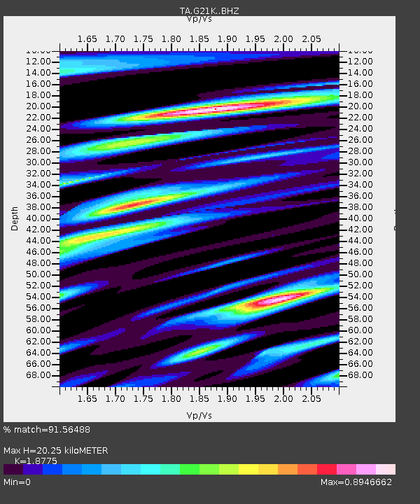
| Estimated Moho Depth: |
20.25 km |
| Estimated Crust Vp/Vs: |
1.88 |
| Assumed Crust Vp: |
6.455 km/s |
| Estimated Crust Vs: |
3.438 km/s |
| Estimated Crust Poisson's Ratio: |
0.30 |
|
| Radial Match: |
91.56488 % |
| Radial Bump: |
400 |
| Transverse Match: |
89.43078 % |
| Transverse Bump: |
400 |
| SOD ConfigId: |
13570011 |
| Insert Time: |
2019-04-30 12:57:09.805 +0000 |
| GWidth: |
2.5 |
| Max Bumps: |
400 |
| Tol: |
0.001 |
|
Signal To Noise
| Channel | StoN | STA | LTA |
| TA:G21K: :BHZ:20180707T11:32:00.499999Z | 5.99431 | 3.1675285E-7 | 5.2842253E-8 |
| TA:G21K: :BHN:20180707T11:32:00.499999Z | 1.2358513 | 6.869742E-8 | 5.5587122E-8 |
| TA:G21K: :BHE:20180707T11:32:00.499999Z | 2.4798434 | 9.097986E-8 | 3.6687744E-8 |
| Arrivals |
| Ps | 2.9 SECOND |
| PpPs | 8.5 SECOND |
| PsPs/PpSs | 11 SECOND |


