You are here: Home > Network List > TA - USArray Transportable Network (new EarthScope stations) Stations List
> Station G29M Pine Creek, YT, CAN > Earthquake Result Viewer
G29M Pine Creek, YT, CAN - Earthquake Result Viewer
| Earthquake location: |
Near East Coast Of Honshu, Japan |
| Earthquake latitude/longitude: |
35.1/140.7 |
| Earthquake time(UTC): |
2018/07/07 (188) 11:23:49 GMT |
| Earthquake Depth: |
39 km |
| Earthquake Magnitude: |
5.9 Mww |
| Earthquake Catalog/Contributor: |
NEIC PDE/us |
|
| Network: |
TA USArray Transportable Network (new EarthScope stations) |
| Station: |
G29M Pine Creek, YT, CAN |
| Lat/Lon: |
66.91 N/138.02 W |
| Elevation: |
572 m |
|
| Distance: |
54.9 deg |
| Az: |
28.451 deg |
| Baz: |
277.868 deg |
| Ray Param: |
0.065053135 |
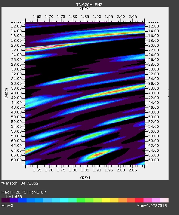
| Estimated Moho Depth: |
20.75 km |
| Estimated Crust Vp/Vs: |
1.66 |
| Assumed Crust Vp: |
6.577 km/s |
| Estimated Crust Vs: |
3.95 km/s |
| Estimated Crust Poisson's Ratio: |
0.22 |
|
| Radial Match: |
84.71062 % |
| Radial Bump: |
400 |
| Transverse Match: |
80.332054 % |
| Transverse Bump: |
400 |
| SOD ConfigId: |
13570011 |
| Insert Time: |
2019-04-30 12:57:15.779 +0000 |
| GWidth: |
2.5 |
| Max Bumps: |
400 |
| Tol: |
0.001 |
|

Signal To Noise
| Channel | StoN | STA | LTA |
| TA:G29M: :BHZ:20180707T11:32:46.100005Z | 9.730591 | 7.4571784E-7 | 7.663644E-8 |
| TA:G29M: :BHN:20180707T11:32:46.100005Z | 0.8694722 | 8.238385E-8 | 9.475156E-8 |
| TA:G29M: :BHE:20180707T11:32:46.100005Z | 4.237399 | 3.3565803E-7 | 7.921322E-8 |
| Arrivals |
| Ps | 2.2 SECOND |
| PpPs | 7.9 SECOND |
| PsPs/PpSs | 10 SECOND |


