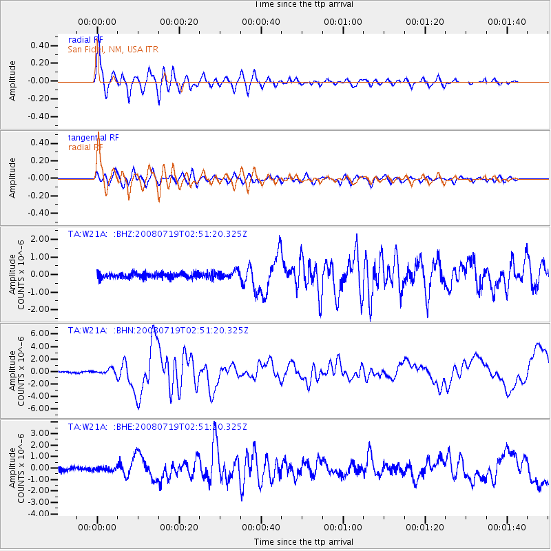
W21A San Fidel, NM, USA - Earthquake Result Viewer
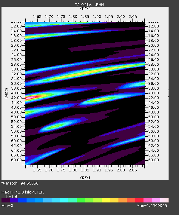
Earthquake location: Off East Coast Of Honshu, Japan
Earthquake latitude/longitude: 37.6/142.2
Earthquake time(UTC): 2008/07/19 (201) 02:39:28 GMT
Earthquake Depth: 22 km
Earthquake Magnitude: 6.2 MB, 7.0 MS, 7.0 MW, 6.9 MW
Earthquake Catalog/Contributor: WHDF/NEIC
Network: TA USArray Transportable Network (new EarthScope stations)
Station: W21A San Fidel, NM, USA
Lat/Lon: 35.12 N/107.65 W
Elevation: 1966 m
Distance: 82.9 deg
Az: 50.858 deg
Baz: 311.244 deg
Ray Param: 0.046529878
Estimated Moho Depth: 42.0 km
Estimated Crust Vp/Vs: 1.60
Assumed Crust Vp: 6.502 km/s
Estimated Crust Vs: 4.063 km/s
Estimated Crust Poisson's Ratio: 0.18
Radial Match: 94.55656 %
Radial Bump: 400
Transverse Match: 86.18632 %
Transverse Bump: 400
SOD ConfigId: 2504
Insert Time: 2010-03-06 12:29:30.879 +0000
GWidth: 2.5
Max Bumps: 400
Tol: 0.001

Signal To Noise

ChannelStoNSTALTA
TA:W21A: :BHN:20080719T02:51:20.325Z4.01937634.4715043E-71.1124872E-7
TA:W21A: :BHE:20080719T02:51:20.325Z1.03024181.6147177E-71.5673191E-7
TA:W21A: :BHZ:20080719T02:51:20.325Z1.40193632.1304722E-71.519664E-7
Arrivals
Ps4.0 SECOND
PpPs16 SECOND
PsPs/PpSs20 SECOND