You are here: Home > Network List > TA - USArray Transportable Network (new EarthScope stations) Stations List
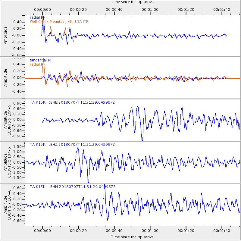
> Station K15K Wolf Creek Mountain, AK, USA > Earthquake Result Viewer
K15K Wolf Creek Mountain, AK, USA - Earthquake Result Viewer
| Earthquake location: |
Near East Coast Of Honshu, Japan |
| Earthquake latitude/longitude: |
35.1/140.7 |
| Earthquake time(UTC): |
2018/07/07 (188) 11:23:49 GMT |
| Earthquake Depth: |
39 km |
| Earthquake Magnitude: |
5.9 Mww |
| Earthquake Catalog/Contributor: |
NEIC PDE/us |
|
| Network: |
TA USArray Transportable Network (new EarthScope stations) |
| Station: |
K15K Wolf Creek Mountain, AK, USA |
| Lat/Lon: |
62.29 N/161.53 W |
| Elevation: |
346 m |
|
| Distance: |
44.8 deg |
| Az: |
34.181 deg |
| Baz: |
260.297 deg |
| Ray Param: |
0.07163325 |
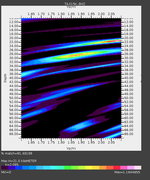
| Estimated Moho Depth: |
21.0 km |
| Estimated Crust Vp/Vs: |
2.10 |
| Assumed Crust Vp: |
6.276 km/s |
| Estimated Crust Vs: |
2.996 km/s |
| Estimated Crust Poisson's Ratio: |
0.35 |
|
| Radial Match: |
91.48189 % |
| Radial Bump: |
400 |
| Transverse Match: |
83.97393 % |
| Transverse Bump: |
400 |
| SOD ConfigId: |
13570011 |
| Insert Time: |
2019-04-30 12:57:56.709 +0000 |
| GWidth: |
2.5 |
| Max Bumps: |
400 |
| Tol: |
0.001 |
|
Signal To Noise
| Channel | StoN | STA | LTA |
| TA:K15K: :BHZ:20180707T11:31:29.049987Z | 4.8959904 | 2.8600581E-7 | 5.8416337E-8 |
| TA:K15K: :BHN:20180707T11:31:29.049987Z | 1.1432259 | 6.183216E-8 | 5.408569E-8 |
| TA:K15K: :BHE:20180707T11:31:29.049987Z | 3.4843323 | 2.0752374E-7 | 5.955911E-8 |
| Arrivals |
| Ps | 3.9 SECOND |
| PpPs | 9.8 SECOND |
| PsPs/PpSs | 14 SECOND |


