You are here: Home > Network List > TA - USArray Transportable Network (new EarthScope stations) Stations List
> Station N14K Kuskokwak Creek, AK, USA > Earthquake Result Viewer
N14K Kuskokwak Creek, AK, USA - Earthquake Result Viewer
| Earthquake location: |
Near East Coast Of Honshu, Japan |
| Earthquake latitude/longitude: |
35.1/140.7 |
| Earthquake time(UTC): |
2018/07/07 (188) 11:23:49 GMT |
| Earthquake Depth: |
39 km |
| Earthquake Magnitude: |
5.9 Mww |
| Earthquake Catalog/Contributor: |
NEIC PDE/us |
|
| Network: |
TA USArray Transportable Network (new EarthScope stations) |
| Station: |
N14K Kuskokwak Creek, AK, USA |
| Lat/Lon: |
59.92 N/161.69 W |
| Elevation: |
21 m |
|
| Distance: |
44.3 deg |
| Az: |
37.518 deg |
| Baz: |
262.541 deg |
| Ray Param: |
0.071897 |
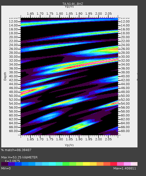
| Estimated Moho Depth: |
53.25 km |
| Estimated Crust Vp/Vs: |
2.10 |
| Assumed Crust Vp: |
6.24 km/s |
| Estimated Crust Vs: |
2.975 km/s |
| Estimated Crust Poisson's Ratio: |
0.35 |
|
| Radial Match: |
86.39487 % |
| Radial Bump: |
400 |
| Transverse Match: |
80.96761 % |
| Transverse Bump: |
400 |
| SOD ConfigId: |
13570011 |
| Insert Time: |
2019-04-30 12:58:26.524 +0000 |
| GWidth: |
2.5 |
| Max Bumps: |
400 |
| Tol: |
0.001 |
|

Signal To Noise
| Channel | StoN | STA | LTA |
| TA:N14K: :BHZ:20180707T11:31:25.624999Z | 5.050477 | 5.137839E-7 | 1.0172977E-7 |
| TA:N14K: :BHN:20180707T11:31:25.624999Z | 0.73985595 | 1.6126485E-7 | 2.1796791E-7 |
| TA:N14K: :BHE:20180707T11:31:25.624999Z | 1.9765254 | 3.8303997E-7 | 1.937946E-7 |
| Arrivals |
| Ps | 9.9 SECOND |
| PpPs | 25 SECOND |
| PsPs/PpSs | 35 SECOND |


