You are here: Home > Network List > TA - USArray Transportable Network (new EarthScope stations) Stations List
> Station N30M Aishikik Lake, Yukon, CAN > Earthquake Result Viewer
N30M Aishikik Lake, Yukon, CAN - Earthquake Result Viewer
| Earthquake location: |
Near East Coast Of Honshu, Japan |
| Earthquake latitude/longitude: |
35.1/140.7 |
| Earthquake time(UTC): |
2018/07/07 (188) 11:23:49 GMT |
| Earthquake Depth: |
39 km |
| Earthquake Magnitude: |
5.9 Mww |
| Earthquake Catalog/Contributor: |
NEIC PDE/us |
|
| Network: |
TA USArray Transportable Network (new EarthScope stations) |
| Station: |
N30M Aishikik Lake, Yukon, CAN |
| Lat/Lon: |
61.46 N/137.09 W |
| Elevation: |
941 m |
|
| Distance: |
56.3 deg |
| Az: |
34.897 deg |
| Baz: |
282.352 deg |
| Ray Param: |
0.06416054 |
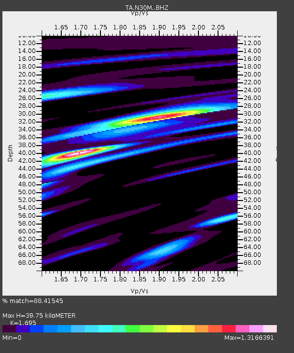
| Estimated Moho Depth: |
39.75 km |
| Estimated Crust Vp/Vs: |
1.70 |
| Assumed Crust Vp: |
6.566 km/s |
| Estimated Crust Vs: |
3.874 km/s |
| Estimated Crust Poisson's Ratio: |
0.23 |
|
| Radial Match: |
88.41545 % |
| Radial Bump: |
400 |
| Transverse Match: |
80.72687 % |
| Transverse Bump: |
400 |
| SOD ConfigId: |
13570011 |
| Insert Time: |
2019-04-30 12:58:32.652 +0000 |
| GWidth: |
2.5 |
| Max Bumps: |
400 |
| Tol: |
0.001 |
|

Signal To Noise
| Channel | StoN | STA | LTA |
| TA:N30M: :BHZ:20180707T11:32:55.899993Z | 4.508502 | 1.8716469E-7 | 4.151372E-8 |
| TA:N30M: :BHN:20180707T11:32:55.899993Z | 1.260312 | 4.8766875E-8 | 3.8694292E-8 |
| TA:N30M: :BHE:20180707T11:32:55.899993Z | 3.5935237 | 1.10962176E-7 | 3.0878375E-8 |
| Arrivals |
| Ps | 4.4 SECOND |
| PpPs | 15 SECOND |
| PsPs/PpSs | 20 SECOND |


