You are here: Home > Network List > TA - USArray Transportable Network (new EarthScope stations) Stations List
> Station O14K Tigyukauivet Mountain, AK, USA > Earthquake Result Viewer
O14K Tigyukauivet Mountain, AK, USA - Earthquake Result Viewer
| Earthquake location: |
Near East Coast Of Honshu, Japan |
| Earthquake latitude/longitude: |
35.1/140.7 |
| Earthquake time(UTC): |
2018/07/07 (188) 11:23:49 GMT |
| Earthquake Depth: |
39 km |
| Earthquake Magnitude: |
5.9 Mww |
| Earthquake Catalog/Contributor: |
NEIC PDE/us |
|
| Network: |
TA USArray Transportable Network (new EarthScope stations) |
| Station: |
O14K Tigyukauivet Mountain, AK, USA |
| Lat/Lon: |
59.25 N/161.26 W |
| Elevation: |
129 m |
|
| Distance: |
44.5 deg |
| Az: |
38.509 deg |
| Baz: |
263.612 deg |
| Ray Param: |
0.071816035 |
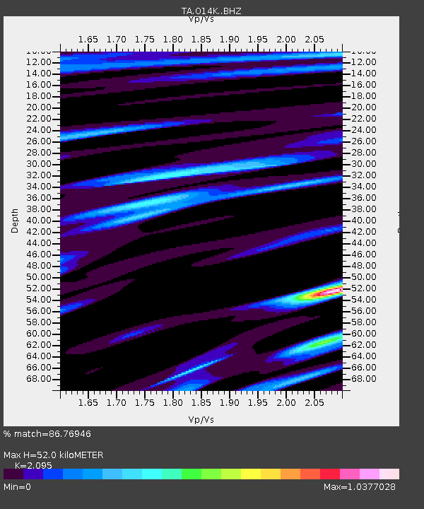
| Estimated Moho Depth: |
52.0 km |
| Estimated Crust Vp/Vs: |
2.10 |
| Assumed Crust Vp: |
6.24 km/s |
| Estimated Crust Vs: |
2.979 km/s |
| Estimated Crust Poisson's Ratio: |
0.35 |
|
| Radial Match: |
86.76946 % |
| Radial Bump: |
400 |
| Transverse Match: |
76.71841 % |
| Transverse Bump: |
400 |
| SOD ConfigId: |
13570011 |
| Insert Time: |
2019-04-30 12:58:35.940 +0000 |
| GWidth: |
2.5 |
| Max Bumps: |
400 |
| Tol: |
0.001 |
|

Signal To Noise
| Channel | StoN | STA | LTA |
| TA:O14K: :BHZ:20180707T11:31:26.700011Z | 4.054171 | 3.0558877E-7 | 7.537639E-8 |
| TA:O14K: :BHN:20180707T11:31:26.700011Z | 0.9601286 | 6.6440634E-8 | 6.919972E-8 |
| TA:O14K: :BHE:20180707T11:31:26.700011Z | 2.125889 | 1.3327661E-7 | 6.269217E-8 |
| Arrivals |
| Ps | 9.6 SECOND |
| PpPs | 25 SECOND |
| PsPs/PpSs | 34 SECOND |


