W21A San Fidel, NM, USA - Earthquake Result Viewer
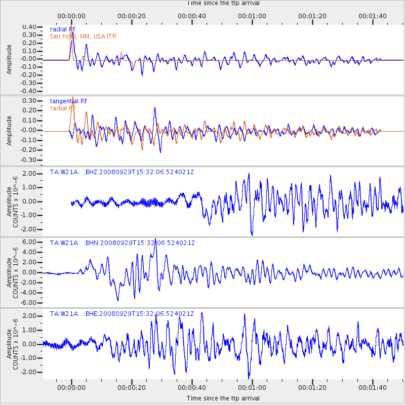
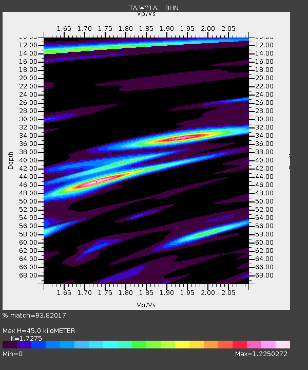
Earthquake location: Kermadec Islands, New Zealand
Earthquake latitude/longitude: -29.8/-177.7
Earthquake time(UTC): 2008/09/29 (273) 15:19:31 GMT
Earthquake Depth: 36 km
Earthquake Magnitude: 6.5 MB, 6.7 MS, 7.0 MW, 7.0 MW
Earthquake Catalog/Contributor: WHDF/NEIC
Network: TA USArray Transportable Network (new EarthScope stations)
Station: W21A San Fidel, NM, USA
Lat/Lon: 35.12 N/107.65 W
Elevation: 1966 m
Distance: 92.3 deg
Az: 50.455 deg
Baz: 234.88 deg
Ray Param: 0.04147599
Estimated Moho Depth: 45.0 km
Estimated Crust Vp/Vs: 1.73
Assumed Crust Vp: 6.502 km/s
Estimated Crust Vs: 3.764 km/s
Estimated Crust Poisson's Ratio: 0.25
Radial Match: 93.82017 %
Radial Bump: 400
Transverse Match: 89.23131 %
Transverse Bump: 400
SOD ConfigId: 2560
Insert Time: 2010-03-06 12:29:52.038 +0000
GWidth: 2.5
Max Bumps: 400
Tol: 0.001

Signal To Noise

ChannelStoNSTALTA
TA:W21A: :BHN:20080929T15:32:06.524021Z5.00223973.6921082E-77.38091E-8
TA:W21A: :BHE:20080929T15:32:06.524021Z1.63301561.841697E-71.127789E-7
TA:W21A: :BHZ:20080929T15:32:06.524021Z0.94801441.4368547E-71.5156465E-7
Arrivals
Ps5.1 SECOND
PpPs18 SECOND
PsPs/PpSs24 SECOND