You are here: Home > Network List > TA - USArray Transportable Network (new EarthScope stations) Stations List
> Station W21A San Fidel, NM, USA > Earthquake Result Viewer
W21A San Fidel, NM, USA - Earthquake Result Viewer
| Earthquake location: |
Kermadec Islands Region |
| Earthquake latitude/longitude: |
-27.4/-176.3 |
| Earthquake time(UTC): |
2009/02/18 (049) 21:53:45 GMT |
| Earthquake Depth: |
25 km |
| Earthquake Magnitude: |
6.8 MB, 7.2 MS, 6.9 MW, 6.9 MW |
| Earthquake Catalog/Contributor: |
WHDF/NEIC |
|
| Network: |
TA USArray Transportable Network (new EarthScope stations) |
| Station: |
W21A San Fidel, NM, USA |
| Lat/Lon: |
35.12 N/107.65 W |
| Elevation: |
1966 m |
|
| Distance: |
89.9 deg |
| Az: |
49.792 deg |
| Baz: |
235.901 deg |
| Ray Param: |
0.04171252 |
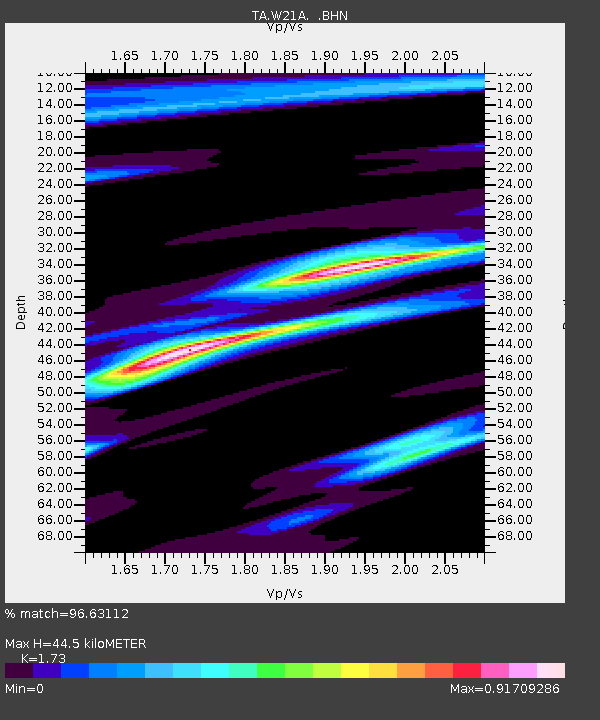
| Estimated Moho Depth: |
44.5 km |
| Estimated Crust Vp/Vs: |
1.73 |
| Assumed Crust Vp: |
6.502 km/s |
| Estimated Crust Vs: |
3.758 km/s |
| Estimated Crust Poisson's Ratio: |
0.25 |
|
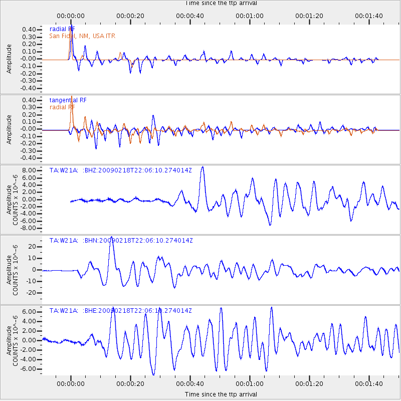
| Radial Match: |
96.63112 % |
| Radial Bump: |
240 |
| Transverse Match: |
93.02593 % |
| Transverse Bump: |
341 |
| SOD ConfigId: |
2658 |
| Insert Time: |
2010-03-06 12:30:08.307 +0000 |
| GWidth: |
2.5 |
| Max Bumps: |
400 |
| Tol: |
0.001 |
|
Signal To Noise
| Channel | StoN | STA | LTA |
| TA:W21A: :BHN:20090218T22:06:10.274014Z | 18.532133 | 2.6109901E-6 | 1.408899E-7 |
| TA:W21A: :BHE:20090218T22:06:10.274014Z | 1.5336237 | 3.7634035E-7 | 2.453929E-7 |
| TA:W21A: :BHZ:20090218T22:06:10.274014Z | 2.9973733 | 8.196051E-7 | 2.7344112E-7 |
| Arrivals |
| Ps | 5.1 SECOND |
| PpPs | 18 SECOND |
| PsPs/PpSs | 23 SECOND |


