You are here: Home > Network List > UW - Pacific Northwest Regional Seismic Network Stations List
> Station UMAT Pilot Rock, OR, USA > Earthquake Result Viewer
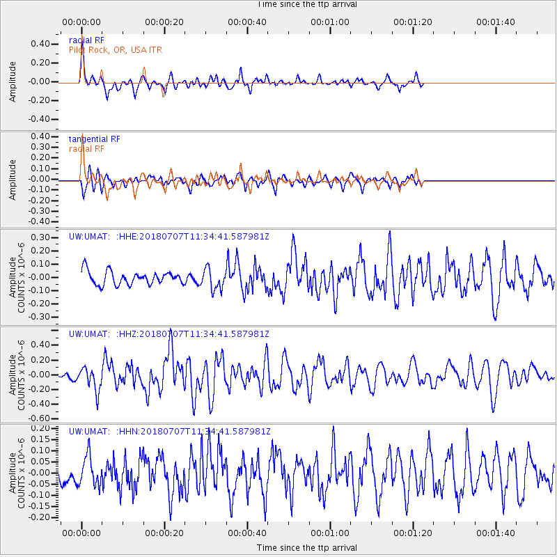
UMAT Pilot Rock, OR, USA - Earthquake Result Viewer
*The percent match for this event was below the threshold and hence no stack was calculated.
| Earthquake location: |
Near East Coast Of Honshu, Japan |
| Earthquake latitude/longitude: |
35.1/140.7 |
| Earthquake time(UTC): |
2018/07/07 (188) 11:23:49 GMT |
| Earthquake Depth: |
39 km |
| Earthquake Magnitude: |
5.9 Mww |
| Earthquake Catalog/Contributor: |
NEIC PDE/us |
|
| Network: |
UW Pacific Northwest Regional Seismic Network |
| Station: |
UMAT Pilot Rock, OR, USA |
| Lat/Lon: |
45.29 N/118.96 W |
| Elevation: |
1318 m |
|
| Distance: |
72.5 deg |
| Az: |
46.727 deg |
| Baz: |
302.238 deg |
| Ray Param: |
$rayparam |
*The percent match for this event was below the threshold and hence was not used in the summary stack. |
|
| Radial Match: |
67.08167 % |
| Radial Bump: |
318 |
| Transverse Match: |
67.65909 % |
| Transverse Bump: |
398 |
| SOD ConfigId: |
13570011 |
| Insert Time: |
2019-04-30 13:00:00.867 +0000 |
| GWidth: |
2.5 |
| Max Bumps: |
400 |
| Tol: |
0.001 |
|
Signal To Noise
| Channel | StoN | STA | LTA |
| UW:UMAT: :HHZ:20180707T11:34:41.587981Z | 2.0190566 | 1.5951814E-7 | 7.900628E-8 |
| UW:UMAT: :HHN:20180707T11:34:41.587981Z | 1.3383371 | 6.6803565E-8 | 4.991535E-8 |
| UW:UMAT: :HHE:20180707T11:34:41.587981Z | 1.5839006 | 7.8882884E-8 | 4.9802928E-8 |
| Arrivals |
| Ps | |
| PpPs | |
| PsPs/PpSs | |


