You are here: Home > Network List > XO18 - AACE: Alaska Amphibious Community seismic Experimen Stations List
> Station EP16 Levelock, AK > Earthquake Result Viewer
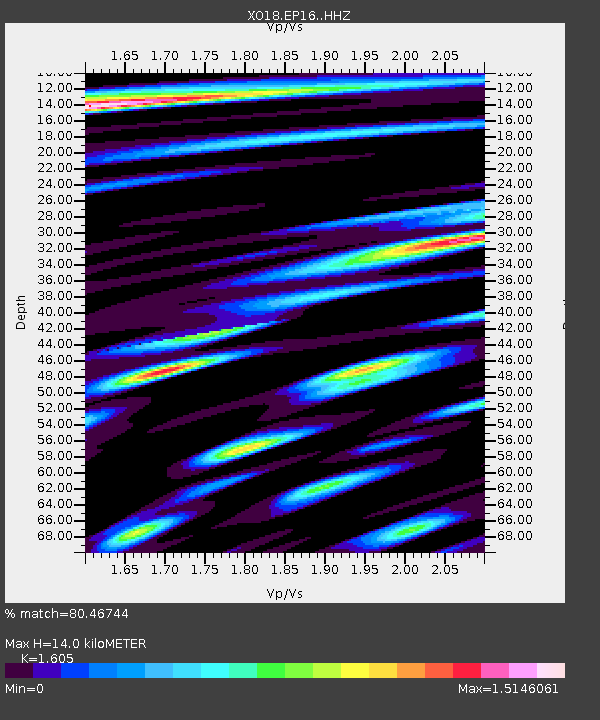
EP16 Levelock, AK - Earthquake Result Viewer
| Earthquake location: |
Near East Coast Of Honshu, Japan |
| Earthquake latitude/longitude: |
35.1/140.7 |
| Earthquake time(UTC): |
2018/07/07 (188) 11:23:49 GMT |
| Earthquake Depth: |
39 km |
| Earthquake Magnitude: |
5.9 Mww |
| Earthquake Catalog/Contributor: |
NEIC PDE/us |
|
| Network: |
XO AACE: Alaska Amphibious Community seismic Experimen |
| Station: |
EP16 Levelock, AK |
| Lat/Lon: |
59.11 N/156.86 W |
| Elevation: |
46 m |
|
| Distance: |
46.7 deg |
| Az: |
38.947 deg |
| Baz: |
267.697 deg |
| Ray Param: |
0.070382215 |
| Estimated Moho Depth: |
14.0 km |
| Estimated Crust Vp/Vs: |
1.61 |
| Assumed Crust Vp: |
6.276 km/s |
| Estimated Crust Vs: |
3.91 km/s |
| Estimated Crust Poisson's Ratio: |
0.18 |
|
| Radial Match: |
80.46744 % |
| Radial Bump: |
400 |
| Transverse Match: |
63.97013 % |
| Transverse Bump: |
400 |
| SOD ConfigId: |
13570011 |
| Insert Time: |
2019-04-30 13:00:16.966 +0000 |
| GWidth: |
2.5 |
| Max Bumps: |
400 |
| Tol: |
0.001 |
|

Signal To Noise
| Channel | StoN | STA | LTA |
| XO:EP16: :HHZ:20180707T11:31:44.450011Z | 4.659261 | 3.832963E-7 | 8.2265466E-8 |
| XO:EP16: :HHN:20180707T11:31:44.450011Z | 1.945189 | 1.6563308E-7 | 8.515012E-8 |
| XO:EP16: :HHE:20180707T11:31:44.450011Z | 3.5765326 | 3.350303E-7 | 9.3674615E-8 |
| Arrivals |
| Ps | 1.4 SECOND |
| PpPs | 5.4 SECOND |
| PsPs/PpSs | 6.9 SECOND |


