You are here: Home > Network List > XO18 - AACE: Alaska Amphibious Community seismic Experimen Stations List
> Station KD12 Anvil Lake, AK > Earthquake Result Viewer
KD12 Anvil Lake, AK - Earthquake Result Viewer
| Earthquake location: |
Near East Coast Of Honshu, Japan |
| Earthquake latitude/longitude: |
35.1/140.7 |
| Earthquake time(UTC): |
2018/07/07 (188) 11:23:49 GMT |
| Earthquake Depth: |
39 km |
| Earthquake Magnitude: |
5.9 Mww |
| Earthquake Catalog/Contributor: |
NEIC PDE/us |
|
| Network: |
XO AACE: Alaska Amphibious Community seismic Experimen |
| Station: |
KD12 Anvil Lake, AK |
| Lat/Lon: |
57.31 N/154.61 W |
| Elevation: |
90 m |
|
| Distance: |
47.9 deg |
| Az: |
41.417 deg |
| Baz: |
271.277 deg |
| Ray Param: |
0.06962421 |
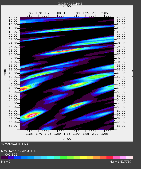
| Estimated Moho Depth: |
27.75 km |
| Estimated Crust Vp/Vs: |
1.83 |
| Assumed Crust Vp: |
6.24 km/s |
| Estimated Crust Vs: |
3.419 km/s |
| Estimated Crust Poisson's Ratio: |
0.29 |
|
| Radial Match: |
83.3874 % |
| Radial Bump: |
400 |
| Transverse Match: |
78.72191 % |
| Transverse Bump: |
400 |
| SOD ConfigId: |
13570011 |
| Insert Time: |
2019-04-30 13:00:22.429 +0000 |
| GWidth: |
2.5 |
| Max Bumps: |
400 |
| Tol: |
0.001 |
|

Signal To Noise
| Channel | StoN | STA | LTA |
| XO:KD12: :HHZ:20180707T11:31:53.559996Z | 4.541267 | 4.1499834E-7 | 9.1383825E-8 |
| XO:KD12: :HHN:20180707T11:31:53.559996Z | 3.8741922 | 2.7885204E-7 | 7.197683E-8 |
| XO:KD12: :HHE:20180707T11:31:53.559996Z | 3.6140459 | 2.9328564E-7 | 8.115161E-8 |
| Arrivals |
| Ps | 3.9 SECOND |
| PpPs | 12 SECOND |
| PsPs/PpSs | 16 SECOND |


