You are here: Home > Network List > TA - USArray Transportable Network (new EarthScope stations) Stations List
> Station W21A San Fidel, NM, USA > Earthquake Result Viewer
W21A San Fidel, NM, USA - Earthquake Result Viewer

| Earthquake location: |
North Of Svalbard |
| Earthquake latitude/longitude: |
80.3/-1.9 |
| Earthquake time(UTC): |
2009/03/06 (065) 10:50:29 GMT |
| Earthquake Depth: |
9.0 km |
| Earthquake Magnitude: |
6.6 MB, 6.5 MS, 6.5 MW, 6.4 MW |
| Earthquake Catalog/Contributor: |
WHDF/NEIC |
|
| Network: |
TA USArray Transportable Network (new EarthScope stations) |
| Station: |
W21A San Fidel, NM, USA |
| Lat/Lon: |
35.12 N/107.65 W |
| Elevation: |
1966 m |
|
| Distance: |
58.2 deg |
| Az: |
291.881 deg |
| Baz: |
11.04 deg |
| Ray Param: |
0.06298884 |
| Estimated Moho Depth: |
44.25 km |
| Estimated Crust Vp/Vs: |
1.60 |
| Assumed Crust Vp: |
6.502 km/s |
| Estimated Crust Vs: |
4.063 km/s |
| Estimated Crust Poisson's Ratio: |
0.18 |
|
| Radial Match: |
93.75227 % |
| Radial Bump: |
392 |
| Transverse Match: |
87.38166 % |
| Transverse Bump: |
348 |
| SOD ConfigId: |
2658 |
| Insert Time: |
2010-03-06 12:30:35.384 +0000 |
| GWidth: |
2.5 |
| Max Bumps: |
400 |
| Tol: |
0.001 |
|
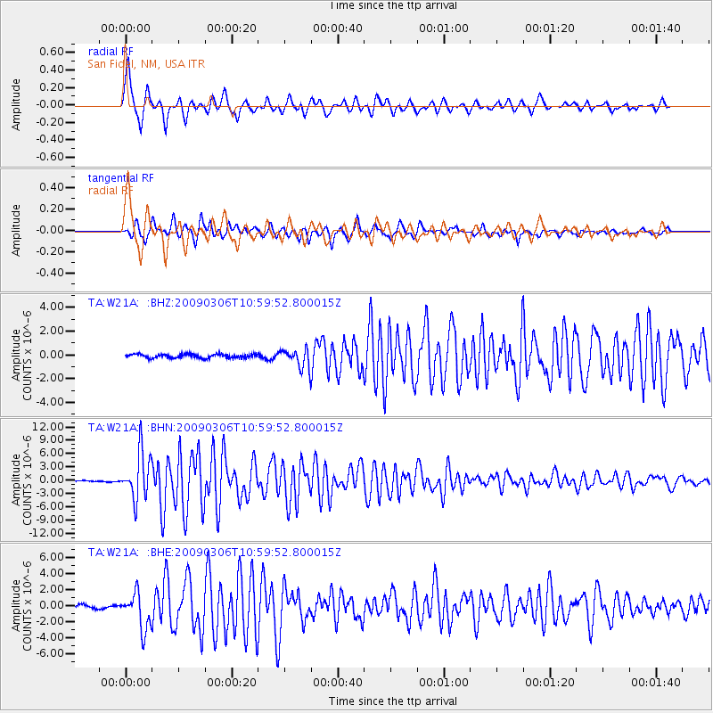
Signal To Noise
| Channel | StoN | STA | LTA |
| TA:W21A: :BHN:20090306T10:59:52.800015Z | 38.4674 | 5.287035E-6 | 1.3744197E-7 |
| TA:W21A: :BHE:20090306T10:59:52.800015Z | 13.237734 | 2.2851461E-6 | 1.7262367E-7 |
| TA:W21A: :BHZ:20090306T10:59:52.800015Z | 5.097385 | 8.2133363E-7 | 1.6112843E-7 |
| Arrivals |
| Ps | 4.3 SECOND |
| PpPs | 17 SECOND |
| PsPs/PpSs | 21 SECOND |


