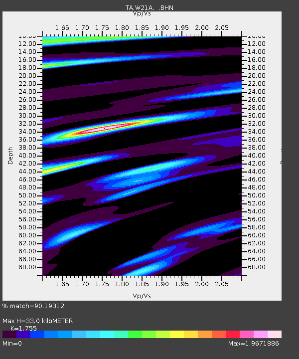
W21A San Fidel, NM, USA - Earthquake Result Viewer
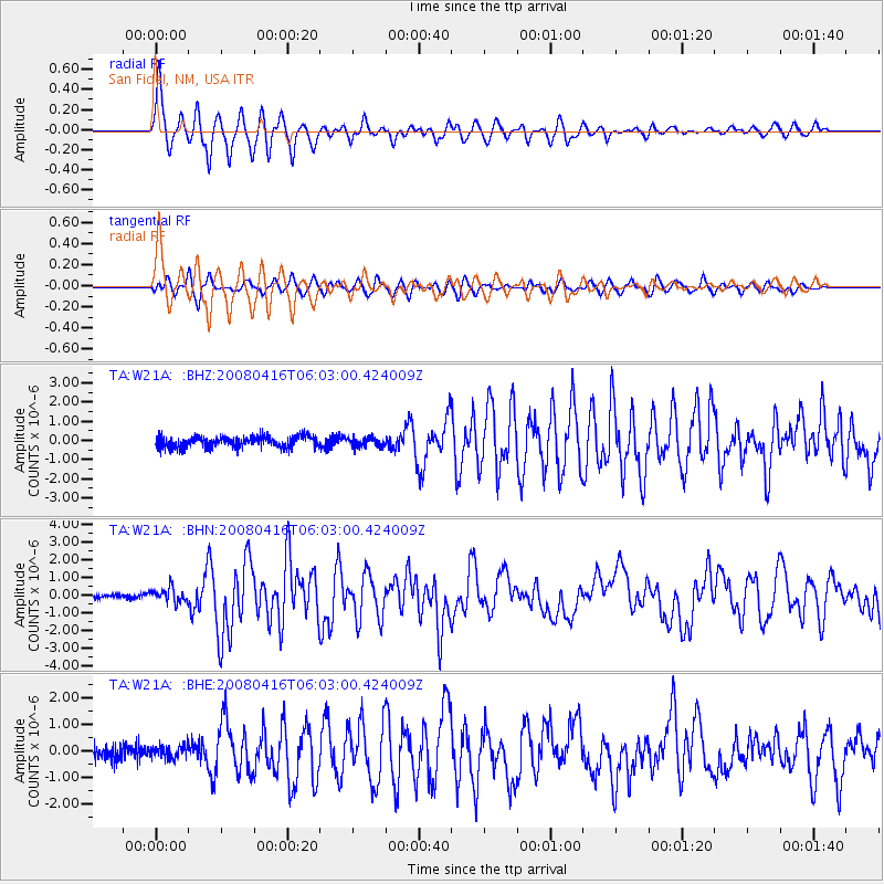
Earthquake location: Andreanof Islands, Aleutian Is.
Earthquake latitude/longitude: 51.9/-179.2
Earthquake time(UTC): 2008/04/16 (107) 05:54:19 GMT
Earthquake Depth: 13 km
Earthquake Magnitude: 6.1 MB, 6.5 MS, 6.6 MW, 6.6 MW
Earthquake Catalog/Contributor: WHDF/NEIC
Network: TA USArray Transportable Network (new EarthScope stations)
Station: W21A San Fidel, NM, USA
Lat/Lon: 35.12 N/107.65 W
Elevation: 1966 m
Distance: 52.4 deg
Az: 79.005 deg
Baz: 312.073 deg
Ray Param: 0.06679111
Estimated Moho Depth: 33.0 km
Estimated Crust Vp/Vs: 1.75
Assumed Crust Vp: 6.502 km/s
Estimated Crust Vs: 3.705 km/s
Estimated Crust Poisson's Ratio: 0.26
Radial Match: 90.19312 %
Radial Bump: 400
Transverse Match: 67.736 %
Transverse Bump: 400
SOD ConfigId: 2504
Insert Time: 2010-03-06 12:31:01.160 +0000
GWidth: 2.5
Max Bumps: 400
Tol: 0.001

Signal To Noise

ChannelStoNSTALTA
TA:W21A: :BHN:20080416T06:03:00.424009Z2.48593024.012745E-71.6141826E-7
TA:W21A: :BHE:20080416T06:03:00.424009Z0.854528252.4464202E-72.8628898E-7
TA:W21A: :BHZ:20080416T06:03:00.424009Z0.772690062.2713837E-72.9395792E-7
Arrivals
Ps4.1 SECOND
PpPs13 SECOND
PsPs/PpSs17 SECOND