You are here: Home > Network List > CI - Caltech Regional Seismic Network Stations List
> Station MPP McPhearson Peak > Earthquake Result Viewer
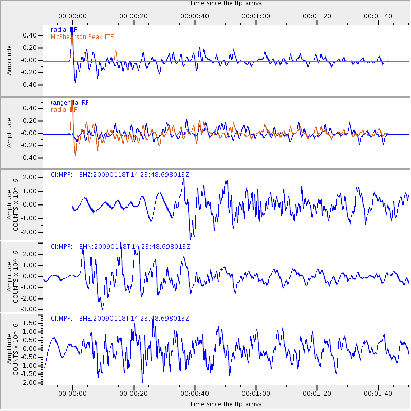
MPP McPhearson Peak - Earthquake Result Viewer
*The percent match for this event was below the threshold and hence no stack was calculated.
| Earthquake location: |
Kermadec Islands, New Zealand |
| Earthquake latitude/longitude: |
-30.2/-178.0 |
| Earthquake time(UTC): |
2009/01/18 (018) 14:11:48 GMT |
| Earthquake Depth: |
33 km |
| Earthquake Magnitude: |
6.0 MB, 6.1 MS, 6.4 MW, 6.4 MW |
| Earthquake Catalog/Contributor: |
WHDF/NEIC |
|
| Network: |
CI Caltech Regional Seismic Network |
| Station: |
MPP McPhearson Peak |
| Lat/Lon: |
34.89 N/119.81 W |
| Elevation: |
1739 m |
|
| Distance: |
84.8 deg |
| Az: |
44.514 deg |
| Baz: |
227.59 deg |
| Ray Param: |
$rayparam |
*The percent match for this event was below the threshold and hence was not used in the summary stack. |
|
| Radial Match: |
50.47226 % |
| Radial Bump: |
400 |
| Transverse Match: |
69.184906 % |
| Transverse Bump: |
400 |
| SOD ConfigId: |
2658 |
| Insert Time: |
2010-02-26 02:04:28.892 +0000 |
| GWidth: |
2.5 |
| Max Bumps: |
400 |
| Tol: |
0.001 |
|
Signal To Noise
| Channel | StoN | STA | LTA |
| CI:MPP: :BHN:20090118T14:23:48.698013Z | 2.9873648 | 9.229008E-7 | 3.0893477E-7 |
| CI:MPP: :BHE:20090118T14:23:48.698013Z | 0.44429156 | 2.86212E-7 | 6.441987E-7 |
| CI:MPP: :BHZ:20090118T14:23:48.698013Z | 1.7263345 | 4.773653E-7 | 2.765196E-7 |
| Arrivals |
| Ps | |
| PpPs | |
| PsPs/PpSs | |


