You are here: Home > Network List > CI - Caltech Regional Seismic Network Stations List
> Station SWS Sam W. Stewart, Westmorland, CA, USA > Earthquake Result Viewer
SWS Sam W. Stewart, Westmorland, CA, USA - Earthquake Result Viewer
| Earthquake location: |
Kermadec Islands, New Zealand |
| Earthquake latitude/longitude: |
-30.6/-178.0 |
| Earthquake time(UTC): |
2018/07/07 (188) 21:33:49 GMT |
| Earthquake Depth: |
34 km |
| Earthquake Magnitude: |
5.9 Mww |
| Earthquake Catalog/Contributor: |
NEIC PDE/us |
|
| Network: |
CI Caltech Regional Seismic Network |
| Station: |
SWS Sam W. Stewart, Westmorland, CA, USA |
| Lat/Lon: |
32.94 N/115.80 W |
| Elevation: |
140 m |
|
| Distance: |
86.4 deg |
| Az: |
48.205 deg |
| Baz: |
229.849 deg |
| Ray Param: |
0.044065736 |
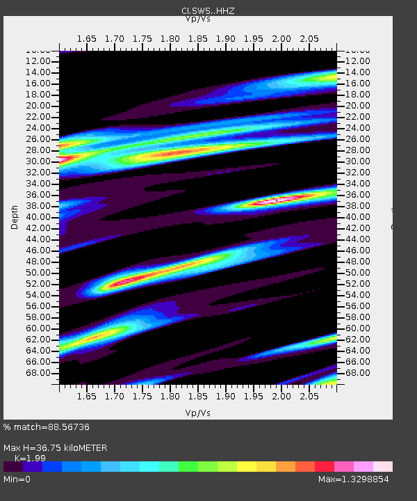
| Estimated Moho Depth: |
36.75 km |
| Estimated Crust Vp/Vs: |
1.99 |
| Assumed Crust Vp: |
6.155 km/s |
| Estimated Crust Vs: |
3.093 km/s |
| Estimated Crust Poisson's Ratio: |
0.33 |
|
| Radial Match: |
88.56736 % |
| Radial Bump: |
400 |
| Transverse Match: |
47.93957 % |
| Transverse Bump: |
400 |
| SOD ConfigId: |
13570011 |
| Insert Time: |
2019-04-30 13:03:49.713 +0000 |
| GWidth: |
2.5 |
| Max Bumps: |
400 |
| Tol: |
0.001 |
|
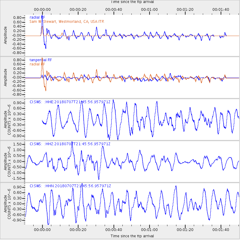
Signal To Noise
| Channel | StoN | STA | LTA |
| CI:SWS: :HHZ:20180707T21:45:56.957971Z | 1.098588 | 3.849633E-7 | 3.5041646E-7 |
| CI:SWS: :HHN:20180707T21:45:56.957971Z | 1.5427128 | 5.9284224E-7 | 3.8428556E-7 |
| CI:SWS: :HHE:20180707T21:45:56.957971Z | 0.79361963 | 3.7563578E-7 | 4.733197E-7 |
| Arrivals |
| Ps | 6.0 SECOND |
| PpPs | 18 SECOND |
| PsPs/PpSs | 24 SECOND |


