You are here: Home > Network List > TA - USArray Transportable Network (new EarthScope stations) Stations List
> Station W21A San Fidel, NM, USA > Earthquake Result Viewer
W21A San Fidel, NM, USA - Earthquake Result Viewer
| Earthquake location: |
Sea Of Okhotsk |
| Earthquake latitude/longitude: |
53.9/152.9 |
| Earthquake time(UTC): |
2008/07/05 (187) 02:12:04 GMT |
| Earthquake Depth: |
633 km |
| Earthquake Magnitude: |
6.8 MB, 7.7 MW, 7.7 MW |
| Earthquake Catalog/Contributor: |
WHDF/NEIC |
|
| Network: |
TA USArray Transportable Network (new EarthScope stations) |
| Station: |
W21A San Fidel, NM, USA |
| Lat/Lon: |
35.12 N/107.65 W |
| Elevation: |
1966 m |
|
| Distance: |
67.6 deg |
| Az: |
61.029 deg |
| Baz: |
320.817 deg |
| Ray Param: |
0.05455056 |
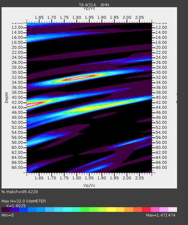
| Estimated Moho Depth: |
32.0 km |
| Estimated Crust Vp/Vs: |
1.80 |
| Assumed Crust Vp: |
6.502 km/s |
| Estimated Crust Vs: |
3.607 km/s |
| Estimated Crust Poisson's Ratio: |
0.28 |
|
| Radial Match: |
89.4228 % |
| Radial Bump: |
400 |
| Transverse Match: |
87.58069 % |
| Transverse Bump: |
400 |
| SOD ConfigId: |
2504 |
| Insert Time: |
2010-03-06 12:31:10.580 +0000 |
| GWidth: |
2.5 |
| Max Bumps: |
400 |
| Tol: |
0.001 |
|
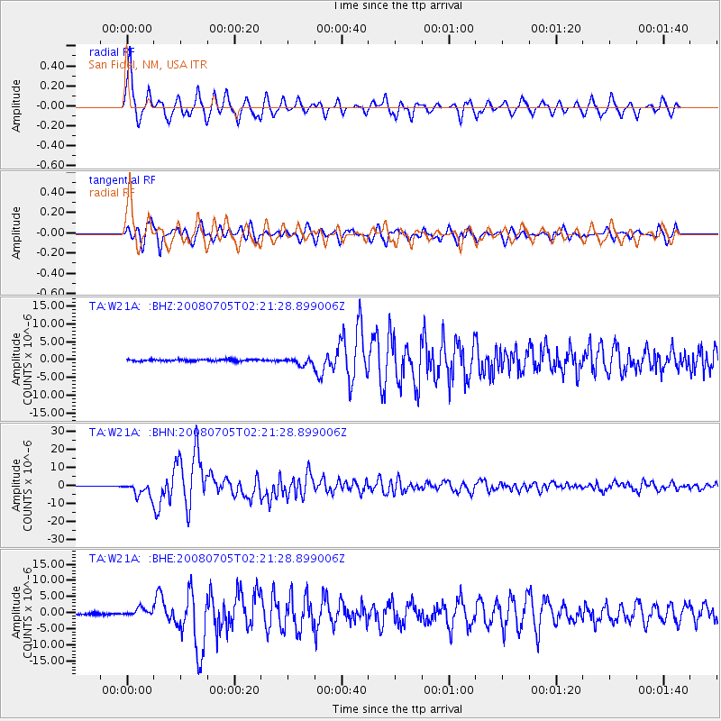
Signal To Noise
| Channel | StoN | STA | LTA |
| TA:W21A: :BHN:20080705T02:21:28.899006Z | 27.370682 | 3.960659E-6 | 1.4470443E-7 |
| TA:W21A: :BHE:20080705T02:21:28.899006Z | 6.124301 | 1.2403979E-6 | 2.0253705E-7 |
| TA:W21A: :BHZ:20080705T02:21:28.899006Z | 4.1775694 | 1.0242188E-6 | 2.45171E-7 |
| Arrivals |
| Ps | 4.1 SECOND |
| PpPs | 13 SECOND |
| PsPs/PpSs | 17 SECOND |


