You are here: Home > Network List > CI - Caltech Regional Seismic Network Stations List
> Station MPP McPhearson Peak > Earthquake Result Viewer
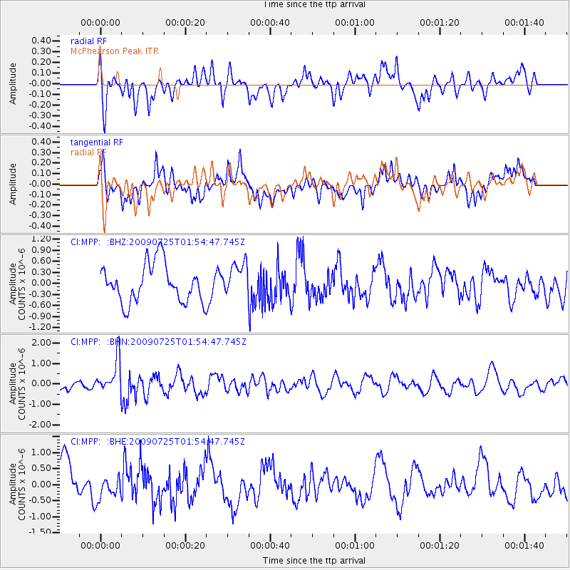
MPP McPhearson Peak - Earthquake Result Viewer
*The percent match for this event was below the threshold and hence no stack was calculated.
| Earthquake location: |
Solomon Islands |
| Earthquake latitude/longitude: |
-6.5/155.0 |
| Earthquake time(UTC): |
2009/07/25 (206) 01:42:23 GMT |
| Earthquake Depth: |
32 km |
| Earthquake Magnitude: |
5.9 MB, 5.7 MS, 5.9 MW, 5.9 MW |
| Earthquake Catalog/Contributor: |
WHDF/NEIC |
|
| Network: |
CI Caltech Regional Seismic Network |
| Station: |
MPP McPhearson Peak |
| Lat/Lon: |
34.89 N/119.81 W |
| Elevation: |
1739 m |
|
| Distance: |
89.8 deg |
| Az: |
55.005 deg |
| Baz: |
261.978 deg |
| Ray Param: |
$rayparam |
*The percent match for this event was below the threshold and hence was not used in the summary stack. |
|
| Radial Match: |
52.18601 % |
| Radial Bump: |
400 |
| Transverse Match: |
57.66508 % |
| Transverse Bump: |
400 |
| SOD ConfigId: |
2648 |
| Insert Time: |
2010-02-26 02:04:29.513 +0000 |
| GWidth: |
2.5 |
| Max Bumps: |
400 |
| Tol: |
0.001 |
|
Signal To Noise
| Channel | StoN | STA | LTA |
| CI:MPP: :BHN:20090725T01:54:47.745Z | 2.2567859 | 8.5521117E-7 | 3.7895094E-7 |
| CI:MPP: :BHE:20090725T01:54:47.745Z | 0.6432433 | 3.7084433E-7 | 5.7652267E-7 |
| CI:MPP: :BHZ:20090725T01:54:47.745Z | 0.8743234 | 4.5375847E-7 | 5.189824E-7 |
| Arrivals |
| Ps | |
| PpPs | |
| PsPs/PpSs | |


