You are here: Home > Network List > TA - USArray Transportable Network (new EarthScope stations) Stations List
> Station L15K Ungalak Mountain, AK, USA > Earthquake Result Viewer
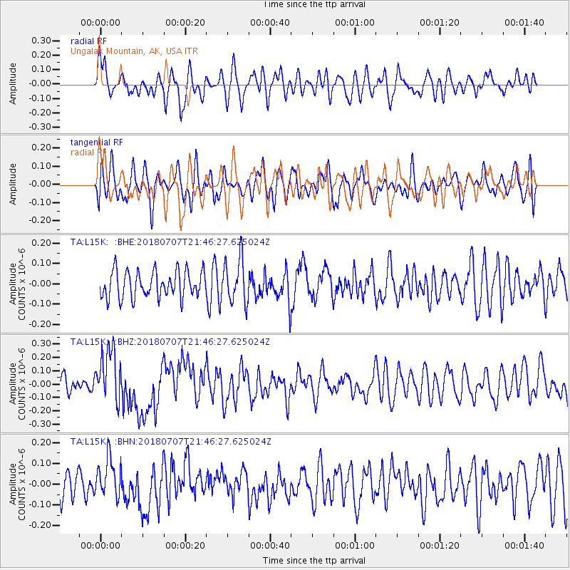
L15K Ungalak Mountain, AK, USA - Earthquake Result Viewer
*The percent match for this event was below the threshold and hence no stack was calculated.
| Earthquake location: |
Kermadec Islands, New Zealand |
| Earthquake latitude/longitude: |
-30.6/-178.0 |
| Earthquake time(UTC): |
2018/07/07 (188) 21:33:49 GMT |
| Earthquake Depth: |
34 km |
| Earthquake Magnitude: |
5.9 Mww |
| Earthquake Catalog/Contributor: |
NEIC PDE/us |
|
| Network: |
TA USArray Transportable Network (new EarthScope stations) |
| Station: |
L15K Ungalak Mountain, AK, USA |
| Lat/Lon: |
61.68 N/161.49 W |
| Elevation: |
219 m |
|
| Distance: |
92.9 deg |
| Az: |
7.812 deg |
| Baz: |
194.223 deg |
| Ray Param: |
$rayparam |
*The percent match for this event was below the threshold and hence was not used in the summary stack. |
|
| Radial Match: |
69.17346 % |
| Radial Bump: |
400 |
| Transverse Match: |
50.10758 % |
| Transverse Bump: |
400 |
| SOD ConfigId: |
13570011 |
| Insert Time: |
2019-04-30 13:05:45.101 +0000 |
| GWidth: |
2.5 |
| Max Bumps: |
400 |
| Tol: |
0.001 |
|
Signal To Noise
| Channel | StoN | STA | LTA |
| TA:L15K: :BHZ:20180707T21:46:27.625024Z | 3.0111425 | 2.012436E-7 | 6.683297E-8 |
| TA:L15K: :BHN:20180707T21:46:27.625024Z | 1.6199167 | 9.783018E-8 | 6.0392104E-8 |
| TA:L15K: :BHE:20180707T21:46:27.625024Z | 1.6922309 | 1.0974109E-7 | 6.484995E-8 |
| Arrivals |
| Ps | |
| PpPs | |
| PsPs/PpSs | |


