You are here: Home > Network List > UW - Pacific Northwest Regional Seismic Network Stations List
> Station LRIV Port Angeles, WA, USA > Earthquake Result Viewer
LRIV Port Angeles, WA, USA - Earthquake Result Viewer
| Earthquake location: |
Kermadec Islands, New Zealand |
| Earthquake latitude/longitude: |
-30.6/-178.0 |
| Earthquake time(UTC): |
2018/07/07 (188) 21:33:49 GMT |
| Earthquake Depth: |
34 km |
| Earthquake Magnitude: |
5.9 Mww |
| Earthquake Catalog/Contributor: |
NEIC PDE/us |
|
| Network: |
UW Pacific Northwest Regional Seismic Network |
| Station: |
LRIV Port Angeles, WA, USA |
| Lat/Lon: |
48.06 N/123.50 W |
| Elevation: |
294 m |
|
| Distance: |
92.3 deg |
| Az: |
33.143 deg |
| Baz: |
224.636 deg |
| Ray Param: |
0.041470673 |
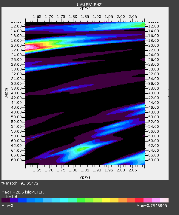
| Estimated Moho Depth: |
20.5 km |
| Estimated Crust Vp/Vs: |
1.60 |
| Assumed Crust Vp: |
6.566 km/s |
| Estimated Crust Vs: |
4.104 km/s |
| Estimated Crust Poisson's Ratio: |
0.18 |
|
| Radial Match: |
91.65472 % |
| Radial Bump: |
400 |
| Transverse Match: |
97.475555 % |
| Transverse Bump: |
165 |
| SOD ConfigId: |
13570011 |
| Insert Time: |
2019-04-30 13:07:07.934 +0000 |
| GWidth: |
2.5 |
| Max Bumps: |
400 |
| Tol: |
0.001 |
|

Signal To Noise
| Channel | StoN | STA | LTA |
| UW:LRIV: :BHZ:20180707T21:46:24.805017Z | 0.811264 | 8.5507827E-7 | 1.0540074E-6 |
| UW:LRIV: :BHN:20180707T21:46:24.805017Z | 0.90751755 | 1.1605533E-6 | 1.278822E-6 |
| UW:LRIV: :BHE:20180707T21:46:24.805017Z | 0.9399684 | 7.007238E-7 | 7.4547586E-7 |
| Arrivals |
| Ps | 1.9 SECOND |
| PpPs | 7.9 SECOND |
| PsPs/PpSs | 9.8 SECOND |


