You are here: Home > Network List > YT07 - POLENET Stations List
> Station THUR THUR > Earthquake Result Viewer
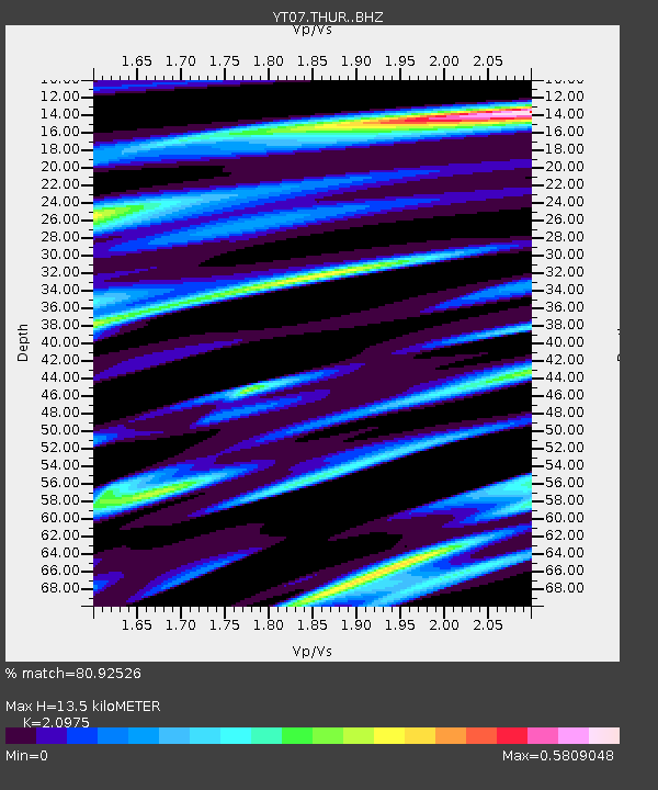
THUR THUR - Earthquake Result Viewer
| Earthquake location: |
Kermadec Islands, New Zealand |
| Earthquake latitude/longitude: |
-30.6/-178.0 |
| Earthquake time(UTC): |
2018/07/07 (188) 21:33:49 GMT |
| Earthquake Depth: |
34 km |
| Earthquake Magnitude: |
5.9 Mww |
| Earthquake Catalog/Contributor: |
NEIC PDE/us |
|
| Network: |
YT POLENET |
| Station: |
THUR THUR |
| Lat/Lon: |
72.53 S/97.56 W |
| Elevation: |
239 m |
|
| Distance: |
58.3 deg |
| Az: |
159.495 deg |
| Baz: |
268.863 deg |
| Ray Param: |
0.062904485 |
| Estimated Moho Depth: |
13.5 km |
| Estimated Crust Vp/Vs: |
2.10 |
| Assumed Crust Vp: |
6.43 km/s |
| Estimated Crust Vs: |
3.065 km/s |
| Estimated Crust Poisson's Ratio: |
0.35 |
|
| Radial Match: |
80.92526 % |
| Radial Bump: |
400 |
| Transverse Match: |
76.79336 % |
| Transverse Bump: |
400 |
| SOD ConfigId: |
13570011 |
| Insert Time: |
2019-04-30 13:07:42.406 +0000 |
| GWidth: |
2.5 |
| Max Bumps: |
400 |
| Tol: |
0.001 |
|

Signal To Noise
| Channel | StoN | STA | LTA |
| YT:THUR: :BHZ:20180707T21:43:10.324976Z | 5.9376984 | 3.223094E-7 | 5.4281877E-8 |
| YT:THUR: :BHN:20180707T21:43:10.324976Z | 0.8281851 | 4.5245546E-8 | 5.463217E-8 |
| YT:THUR: :BHE:20180707T21:43:10.324976Z | 2.7612824 | 2.3820944E-7 | 8.626768E-8 |
| Arrivals |
| Ps | 2.4 SECOND |
| PpPs | 6.2 SECOND |
| PsPs/PpSs | 8.6 SECOND |


