You are here: Home > Network List > TA - USArray Transportable Network (new EarthScope stations) Stations List
> Station W21A San Fidel, NM, USA > Earthquake Result Viewer
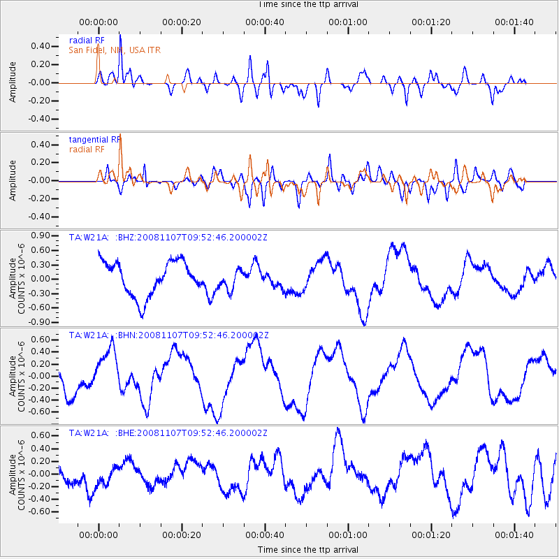
W21A San Fidel, NM, USA - Earthquake Result Viewer
*The percent match for this event was below the threshold and hence no stack was calculated.
| Earthquake location: |
Vanuatu Islands |
| Earthquake latitude/longitude: |
-14.9/168.1 |
| Earthquake time(UTC): |
2008/11/07 (312) 09:40:00 GMT |
| Earthquake Depth: |
10 km |
| Earthquake Magnitude: |
5.5 MB, 4.9 MS, 5.5 MW |
| Earthquake Catalog/Contributor: |
WHDF/NEIC |
|
| Network: |
TA USArray Transportable Network (new EarthScope stations) |
| Station: |
W21A San Fidel, NM, USA |
| Lat/Lon: |
35.12 N/107.65 W |
| Elevation: |
1966 m |
|
| Distance: |
93.8 deg |
| Az: |
54.833 deg |
| Baz: |
254.572 deg |
| Ray Param: |
$rayparam |
*The percent match for this event was below the threshold and hence was not used in the summary stack. |
|
| Radial Match: |
87.143265 % |
| Radial Bump: |
400 |
| Transverse Match: |
69.7877 % |
| Transverse Bump: |
400 |
| SOD ConfigId: |
2658 |
| Insert Time: |
2010-03-06 12:32:29.553 +0000 |
| GWidth: |
2.5 |
| Max Bumps: |
400 |
| Tol: |
0.001 |
|
Signal To Noise
| Channel | StoN | STA | LTA |
| TA:W21A: :BHN:20081107T09:52:46.200002Z | 1.8442949 | 3.935786E-7 | 2.134033E-7 |
| TA:W21A: :BHE:20081107T09:52:46.200002Z | 0.73873115 | 1.5241136E-7 | 2.0631506E-7 |
| TA:W21A: :BHZ:20081107T09:52:46.200002Z | 0.5889306 | 2.0630122E-7 | 3.50298E-7 |
| Arrivals |
| Ps | |
| PpPs | |
| PsPs/PpSs | |


