You are here: Home > Network List > G - GEOSCOPE Stations List
> Station DRV Dumont d'Urville, Terre Adelie (Antartica) > Earthquake Result Viewer
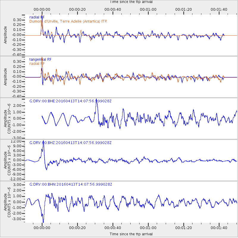
DRV Dumont d'Urville, Terre Adelie (Antartica) - Earthquake Result Viewer
*The percent match for this event was below the threshold and hence no stack was calculated.
| Earthquake location: |
Myanmar-India Border Region |
| Earthquake latitude/longitude: |
23.1/94.9 |
| Earthquake time(UTC): |
2016/04/13 (104) 13:55:17 GMT |
| Earthquake Depth: |
135 km |
| Earthquake Magnitude: |
6.9 MWB |
| Earthquake Catalog/Contributor: |
NEIC PDE/NEIC COMCAT |
|
| Network: |
G GEOSCOPE |
| Station: |
DRV Dumont d'Urville, Terre Adelie (Antartica) |
| Lat/Lon: |
66.67 S/140.01 E |
| Elevation: |
40 m |
|
| Distance: |
95.7 deg |
| Az: |
163.523 deg |
| Baz: |
319.048 deg |
| Ray Param: |
$rayparam |
*The percent match for this event was below the threshold and hence was not used in the summary stack. |
|
| Radial Match: |
76.9425 % |
| Radial Bump: |
400 |
| Transverse Match: |
65.81697 % |
| Transverse Bump: |
400 |
| SOD ConfigId: |
1609551 |
| Insert Time: |
2016-06-22 14:40:00.375 +0000 |
| GWidth: |
2.5 |
| Max Bumps: |
400 |
| Tol: |
0.001 |
|
Signal To Noise
| Channel | StoN | STA | LTA |
| G:DRV:00:BHZ:20160413T14:07:56.999028Z | 10.049144 | 5.3067315E-6 | 5.28078E-7 |
| G:DRV:00:BHN:20160413T14:07:56.999028Z | 3.9158747 | 1.604796E-6 | 4.0981803E-7 |
| G:DRV:00:BHE:20160413T14:07:56.999028Z | 2.4154978 | 1.3004754E-6 | 5.383881E-7 |
| Arrivals |
| Ps | |
| PpPs | |
| PsPs/PpSs | |


