You are here: Home > Network List > TA - USArray Transportable Network (new EarthScope stations) Stations List
> Station W21A San Fidel, NM, USA > Earthquake Result Viewer
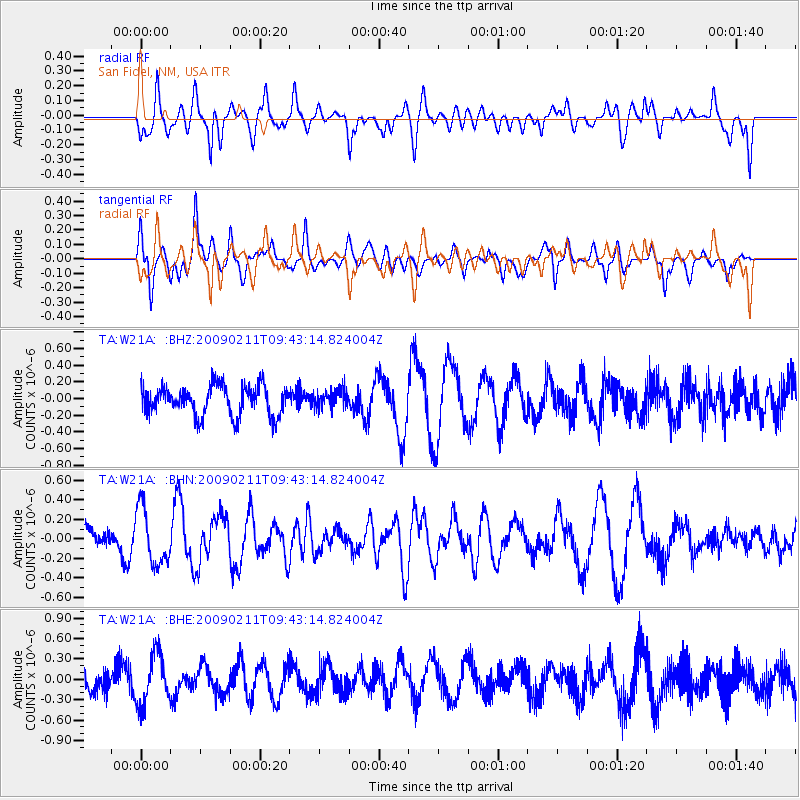
W21A San Fidel, NM, USA - Earthquake Result Viewer
*The percent match for this event was below the threshold and hence no stack was calculated.
| Earthquake location: |
Fiji Islands Region |
| Earthquake latitude/longitude: |
-20.8/-177.3 |
| Earthquake time(UTC): |
2009/02/11 (042) 09:31:04 GMT |
| Earthquake Depth: |
10 km |
| Earthquake Magnitude: |
5.5 MB, 5.2 MS, 5.5 MW, 5.5 MW |
| Earthquake Catalog/Contributor: |
WHDF/NEIC |
|
| Network: |
TA USArray Transportable Network (new EarthScope stations) |
| Station: |
W21A San Fidel, NM, USA |
| Lat/Lon: |
35.12 N/107.65 W |
| Elevation: |
1966 m |
|
| Distance: |
86.3 deg |
| Az: |
50.376 deg |
| Baz: |
241.548 deg |
| Ray Param: |
$rayparam |
*The percent match for this event was below the threshold and hence was not used in the summary stack. |
|
| Radial Match: |
51.271214 % |
| Radial Bump: |
400 |
| Transverse Match: |
56.289547 % |
| Transverse Bump: |
400 |
| SOD ConfigId: |
2658 |
| Insert Time: |
2010-03-06 12:33:24.662 +0000 |
| GWidth: |
2.5 |
| Max Bumps: |
400 |
| Tol: |
0.001 |
|
Signal To Noise
| Channel | StoN | STA | LTA |
| TA:W21A: :BHN:20090211T09:43:14.824004Z | 2.453249 | 2.8655606E-7 | 1.1680675E-7 |
| TA:W21A: :BHE:20090211T09:43:14.824004Z | 2.7777548 | 3.657245E-7 | 1.3166192E-7 |
| TA:W21A: :BHZ:20090211T09:43:14.824004Z | 0.6161442 | 1.0991934E-7 | 1.7839875E-7 |
| Arrivals |
| Ps | |
| PpPs | |
| PsPs/PpSs | |


