You are here: Home > Network List > TA - USArray Transportable Network (new EarthScope stations) Stations List
> Station W21A San Fidel, NM, USA > Earthquake Result Viewer
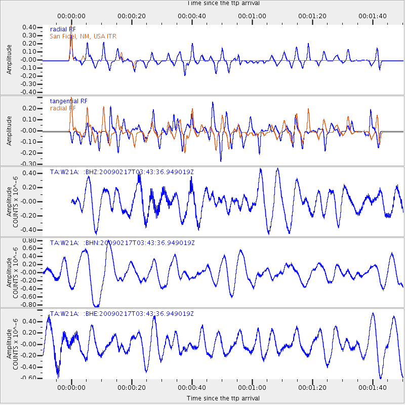
W21A San Fidel, NM, USA - Earthquake Result Viewer
*The percent match for this event was below the threshold and hence no stack was calculated.
| Earthquake location: |
Kermadec Islands, New Zealand |
| Earthquake latitude/longitude: |
-30.7/-178.6 |
| Earthquake time(UTC): |
2009/02/17 (048) 03:30:53 GMT |
| Earthquake Depth: |
13 km |
| Earthquake Magnitude: |
5.5 MS, 5.4 MB, 6.0 MW, 6.0 MW |
| Earthquake Catalog/Contributor: |
WHDF/NEIC |
|
| Network: |
TA USArray Transportable Network (new EarthScope stations) |
| Station: |
W21A San Fidel, NM, USA |
| Lat/Lon: |
35.12 N/107.65 W |
| Elevation: |
1966 m |
|
| Distance: |
93.5 deg |
| Az: |
50.935 deg |
| Baz: |
234.646 deg |
| Ray Param: |
$rayparam |
*The percent match for this event was below the threshold and hence was not used in the summary stack. |
|
| Radial Match: |
47.390514 % |
| Radial Bump: |
400 |
| Transverse Match: |
59.157276 % |
| Transverse Bump: |
400 |
| SOD ConfigId: |
2658 |
| Insert Time: |
2010-03-06 12:33:41.262 +0000 |
| GWidth: |
2.5 |
| Max Bumps: |
400 |
| Tol: |
0.001 |
|
Signal To Noise
| Channel | StoN | STA | LTA |
| TA:W21A: :BHN:20090217T03:43:36.949019Z | 2.8385296 | 3.839197E-7 | 1.3525303E-7 |
| TA:W21A: :BHE:20090217T03:43:36.949019Z | 0.68009776 | 1.4515244E-7 | 2.1342879E-7 |
| TA:W21A: :BHZ:20090217T03:43:36.949019Z | 0.49537218 | 9.34468E-8 | 1.8863959E-7 |
| Arrivals |
| Ps | |
| PpPs | |
| PsPs/PpSs | |


