You are here: Home > Network List > TA - USArray Transportable Network (new EarthScope stations) Stations List
> Station W21A San Fidel, NM, USA > Earthquake Result Viewer
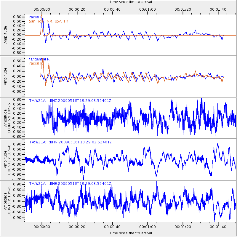
W21A San Fidel, NM, USA - Earthquake Result Viewer
*The percent match for this event was below the threshold and hence no stack was calculated.
| Earthquake location: |
Kodiak Island Region, Alaska |
| Earthquake latitude/longitude: |
56.4/-152.4 |
| Earthquake time(UTC): |
2009/05/16 (136) 18:22:25 GMT |
| Earthquake Depth: |
9.7 km |
| Earthquake Magnitude: |
5.9 MS, 5.4 MB, 5.9 MW, 5.8 MW |
| Earthquake Catalog/Contributor: |
WHDF/NEIC |
|
| Network: |
TA USArray Transportable Network (new EarthScope stations) |
| Station: |
W21A San Fidel, NM, USA |
| Lat/Lon: |
35.12 N/107.65 W |
| Elevation: |
1966 m |
|
| Distance: |
36.9 deg |
| Az: |
106.019 deg |
| Baz: |
319.364 deg |
| Ray Param: |
$rayparam |
*The percent match for this event was below the threshold and hence was not used in the summary stack. |
|
| Radial Match: |
78.89501 % |
| Radial Bump: |
400 |
| Transverse Match: |
67.35267 % |
| Transverse Bump: |
400 |
| SOD ConfigId: |
2760 |
| Insert Time: |
2010-03-06 12:33:43.630 +0000 |
| GWidth: |
2.5 |
| Max Bumps: |
400 |
| Tol: |
0.001 |
|
Signal To Noise
| Channel | StoN | STA | LTA |
| TA:W21A: :BHN:20090516T18:29:03.52401Z | 1.3092972 | 1.3145001E-7 | 1.0039738E-7 |
| TA:W21A: :BHE:20090516T18:29:03.52401Z | 1.8105869 | 3.7129402E-7 | 2.0506833E-7 |
| TA:W21A: :BHZ:20090516T18:29:03.52401Z | 0.77824754 | 1.9361494E-7 | 2.4878324E-7 |
| Arrivals |
| Ps | |
| PpPs | |
| PsPs/PpSs | |


