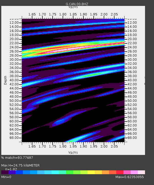
CAN Canberra, Australia - Earthquake Result Viewer

Earthquake location: Southern Sumatra, Indonesia
Earthquake latitude/longitude: -2.1/100.7
Earthquake time(UTC): 2016/06/01 (153) 22:56:00 GMT
Earthquake Depth: 50 km
Earthquake Magnitude: 6.6 MWW, 6.4 MWB, 6.6 MWC, 6.7 MWC
Earthquake Catalog/Contributor: NEIC PDE/NEIC COMCAT
Network: G GEOSCOPE
Station: CAN Canberra, Australia
Lat/Lon: 35.32 S/149.00 E
Elevation: 650 m
Distance: 55.7 deg
Az: 132.283 deg
Baz: 295.294 deg
Ray Param: 0.06453005
Estimated Moho Depth: 24.75 km
Estimated Crust Vp/Vs: 1.82
Assumed Crust Vp: 6.633 km/s
Estimated Crust Vs: 3.645 km/s
Estimated Crust Poisson's Ratio: 0.28
Radial Match: 93.77697 %
Radial Bump: 400
Transverse Match: 85.86195 %
Transverse Bump: 400
SOD ConfigId: 1609551
Insert Time: 2016-06-22 14:45:42.408 +0000
GWidth: 2.5
Max Bumps: 400
Tol: 0.001

Signal To Noise

ChannelStoNSTALTA
G:CAN:00:BHZ:20160601T23:05:01.199998Z17.0292363.331164E-61.956144E-7
G:CAN:00:BHN:20160601T23:05:01.199998Z4.9306939.0426386E-71.8339487E-7
G:CAN:00:BHE:20160601T23:05:01.199998Z7.5553011.2697989E-61.6806727E-7
Arrivals
Ps3.2 SECOND
PpPs10.0 SECOND
PsPs/PpSs13 SECOND