You are here: Home > Network List > G - GEOSCOPE Stations List
> Station CRZF Port Alfred, Crozet, South Indian Ocean > Earthquake Result Viewer
CRZF Port Alfred, Crozet, South Indian Ocean - Earthquake Result Viewer
| Earthquake location: |
Southern Sumatra, Indonesia |
| Earthquake latitude/longitude: |
-2.1/100.7 |
| Earthquake time(UTC): |
2016/06/01 (153) 22:56:00 GMT |
| Earthquake Depth: |
50 km |
| Earthquake Magnitude: |
6.6 MWW, 6.4 MWB, 6.6 MWC, 6.7 MWC |
| Earthquake Catalog/Contributor: |
NEIC PDE/NEIC COMCAT |
|
| Network: |
G GEOSCOPE |
| Station: |
CRZF Port Alfred, Crozet, South Indian Ocean |
| Lat/Lon: |
46.43 S/51.86 E |
| Elevation: |
140 m |
|
| Distance: |
61.2 deg |
| Az: |
216.428 deg |
| Baz: |
59.087 deg |
| Ray Param: |
0.06089983 |
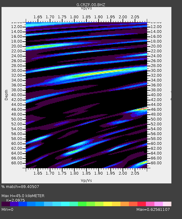
| Estimated Moho Depth: |
45.0 km |
| Estimated Crust Vp/Vs: |
2.10 |
| Assumed Crust Vp: |
4.802 km/s |
| Estimated Crust Vs: |
2.289 km/s |
| Estimated Crust Poisson's Ratio: |
0.35 |
|
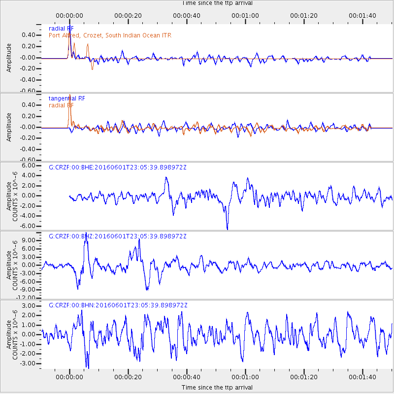
| Radial Match: |
89.40507 % |
| Radial Bump: |
400 |
| Transverse Match: |
80.15852 % |
| Transverse Bump: |
400 |
| SOD ConfigId: |
1609551 |
| Insert Time: |
2016-06-22 14:45:50.550 +0000 |
| GWidth: |
2.5 |
| Max Bumps: |
400 |
| Tol: |
0.001 |
|
Signal To Noise
| Channel | StoN | STA | LTA |
| G:CRZF:00:BHZ:20160601T23:05:39.898972Z | 3.9016209 | 3.5068754E-6 | 8.9882525E-7 |
| G:CRZF:00:BHN:20160601T23:05:39.898972Z | 2.1450086 | 1.2084166E-6 | 5.633621E-7 |
| G:CRZF:00:BHE:20160601T23:05:39.898972Z | 2.927057 | 1.7030382E-6 | 5.818261E-7 |
| Arrivals |
| Ps | 11 SECOND |
| PpPs | 28 SECOND |
| PsPs/PpSs | 39 SECOND |


