You are here: Home > Network List > CI - Caltech Regional Seismic Network Stations List
> Station MPP McPhearson Peak > Earthquake Result Viewer
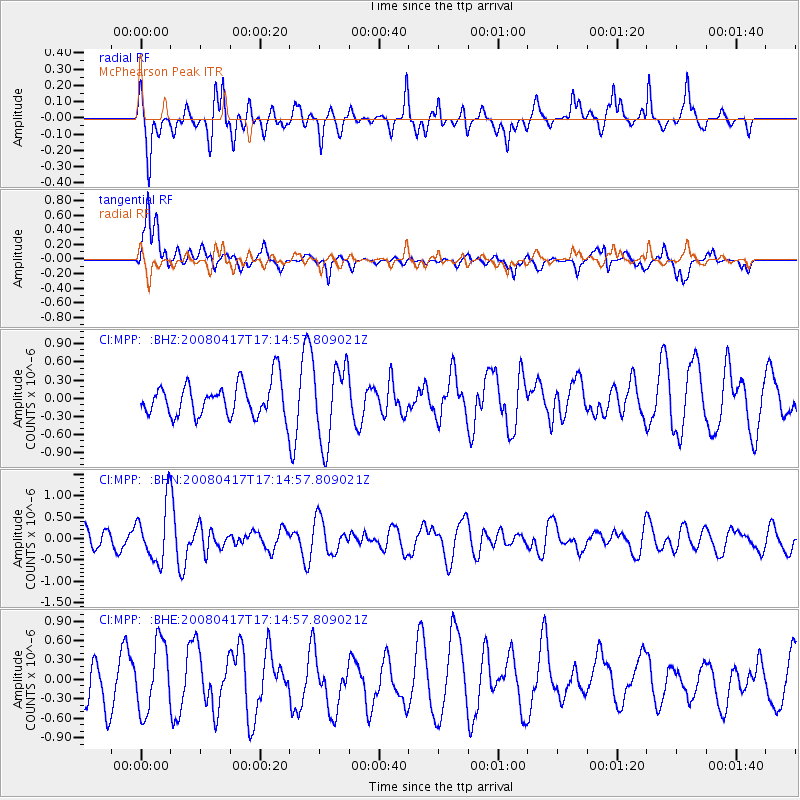
MPP McPhearson Peak - Earthquake Result Viewer
*The percent match for this event was below the threshold and hence no stack was calculated.
| Earthquake location: |
Mariana Islands Region |
| Earthquake latitude/longitude: |
15.9/144.9 |
| Earthquake time(UTC): |
2008/04/17 (108) 17:02:52 GMT |
| Earthquake Depth: |
10 km |
| Earthquake Magnitude: |
5.5 MB, 5.2 MS, 5.5 MW, 5.5 MW |
| Earthquake Catalog/Contributor: |
WHDF/NEIC |
|
| Network: |
CI Caltech Regional Seismic Network |
| Station: |
MPP McPhearson Peak |
| Lat/Lon: |
34.89 N/119.81 W |
| Elevation: |
1739 m |
|
| Distance: |
85.3 deg |
| Az: |
55.213 deg |
| Baz: |
285.975 deg |
| Ray Param: |
$rayparam |
*The percent match for this event was below the threshold and hence was not used in the summary stack. |
|
| Radial Match: |
70.0162 % |
| Radial Bump: |
400 |
| Transverse Match: |
73.07148 % |
| Transverse Bump: |
400 |
| SOD ConfigId: |
2504 |
| Insert Time: |
2010-02-26 02:04:35.080 +0000 |
| GWidth: |
2.5 |
| Max Bumps: |
400 |
| Tol: |
0.001 |
|
Signal To Noise
| Channel | StoN | STA | LTA |
| CI:MPP: :BHN:20080417T17:14:57.809021Z | 1.5792236 | 6.648291E-7 | 4.2098478E-7 |
| CI:MPP: :BHE:20080417T17:14:57.809021Z | 1.0063531 | 5.265964E-7 | 5.2327204E-7 |
| CI:MPP: :BHZ:20080417T17:14:57.809021Z | 2.2755778 | 6.3018814E-7 | 2.7693545E-7 |
| Arrivals |
| Ps | |
| PpPs | |
| PsPs/PpSs | |


